Science Score: 67.0%
This score indicates how likely this project is to be science-related based on various indicators:
-
✓CITATION.cff file
Found CITATION.cff file -
✓codemeta.json file
Found codemeta.json file -
✓.zenodo.json file
Found .zenodo.json file -
✓DOI references
Found 4 DOI reference(s) in README -
✓Academic publication links
Links to: sciencedirect.com, wiley.com, science.org, mdpi.com, iop.org, zenodo.org -
○Committers with academic emails
-
○Institutional organization owner
-
○JOSS paper metadata
-
○Scientific vocabulary similarity
Low similarity (6.5%) to scientific vocabulary
Keywords
Repository
Overview of Digital Elevation Model (DEM) datasets
Basic Info
Statistics
- Stars: 412
- Watchers: 11
- Forks: 27
- Open Issues: 5
- Releases: 0
Topics
Metadata Files
README.md

Contents
- Contents
- Introduction
- Links
- Data
- Global, open
- Summary
- ASTER GDEM
- SRTM DEM
- NASADEM
- ALOS World 3D-30m
- Copernicus DEM
- MERIT
- FABDEM
- TanDEM-X
- Global, proprietary
- WorldDEM and TanDEM-X
- Vricon
- Global bathymetric, open
- ETOPO1
- GMRT
- GEBCO
- SRTM15+
- Local, open
- EU-DEM
- EU-DTM
- US: 3DEP
- ArcticDEM
- Arctic: REMA
- Australia: Elvis - Elevation and Depth
- France: Litto3D
- France: RGE ALTI
- France: HD-LIDAR
- Italy: Tinitaly DEM
- Switzerland: SwissALTI3D
- High Mountain Asia DEM
- New Zealand: LINZ DEMs & Related
- Non-terrestrial, open
- Lunar Orbiter Laser Altimeter (LOLA)
- Pluto New Horizon
- Mars Orbiter Laser Altimeter (MOLA)
- Charon New Horizon
- Mercury Messenger
- Venus Magellan
Introduction
A Digital Elevation Model (DEM) represents the elevation of the surface.
DEM vs DSM vs DTM
It is useful to distinguish between DSM and DTM.
- Digital Surface Model (DSM): Includes objects on the surface, such as trees and buildings.
- Digital Terrain Model (DTM): Represents the bare surface.
In this repo, DEM is a generic term referring to either a DSM or a DTM. Note however that DEM is often also equated with DTM.
This graphic from Neon summarizes the differences well:
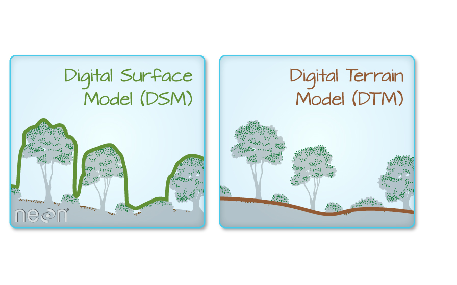
For a more detailed discussion, see Digital Elevation Models: Terminology and Definitions.
Links
Papers
- Vertical Accuracy of Freely Available Global Digital Elevation Models (ASTER, AW3D30, MERIT, TanDEM-X, SRTM, and NASADEM)
- Comparative accuracy of the AW3D30 DSM, ASTER GDEM, and SRTM1 DEM: A case study on the Zaoksky testing ground, Central European Russia
- Accuracy assessment of the TanDEM-X 90 Digital Elevation Model for selected floodplain sites
- Evaluation of TanDEM-X DEMs on selected Brazilian sites: Comparison with SRTM, ASTER GDEM and ALOS AW3D30
Portals
- OpenTopography
- AWS Open Data
- Microsoft Planetary Computer Data Catalog
- Google Earth Engine Data Catalog
- Sentinel Hub
Discussion
Data
Global, open
Summary
| Dataset | Type | Horizontal resolution (m) | Vertical accuracy (m) | Data collection period | Method | Notes | |:------------------|:-------|:----------------------------|:------------------------|:-------------------------|:-----------------------|:--------------------------------------------------| | ASTER GDEM V3 | DSM | 30 | 17 | 2000-2011 | Photogrammetry | | | SRTM DEM V3 | DSM | 30 USA, 90 outside | 9 | 2000 | InSAR | Coverage between 60° north and 56° south latitude | | NASADEM | DSM | 30 | | 2000 | InSAR | Reprocessing of SRTM | | AW3D30 | DSM | 30 | 5 | 2006-2011 | Photogrammetry | | | COPERNICUS GLO-30 | DSM | 30 | 4 | 2011-2015 | InSAR | Based on WorldDEM | | MERIT | DSM | 90 | 12 | 2000, 2006-2011 | InSAR + Photogrammetry | Created from SRTM + AW3D30 | | FABDEM | DTM | 30 | 1.12-2.88 (mean error) | 2011-2015 | InSAR | Used ML to remove buildings+trees from GLO-30 | | TanDEM-X 90m | DSM | 90 | 10 | 2010-2015 | InSAR | |
Which DEM is derived from which base dataset?

ASTER GDEM
Advanced Spaceborne Thermal Emission and Reflection satellite - Optical sensor, stereopair images
Products
- ASTER GDEM2: Released 2011, acquired more scenes 2008-2011
- ASTER GDEM3
Links
SRTM DEM
Shuttle Radar Topography Mission - NASA + NGA - Space shuttle Endeavour

Coverage is only between 60° north and 56° south latitude
Products
- SRTM Non-Void Filled
- SRTM Void Filled: More processing to fill missing data (not actually missing, but low quality)
- SRTM 1 Arc-Second Global
Links
NASADEM
Reprocessing of SRTM - Using the latest unwrapping techniques - More voids filled with auxiliary data - ASTER GDEM, Advanced Land Observing Satellite (ALOS) Panchromatic Remote sensing Instrument for Stereo Mapping (PRISM), USGS National Elevation Dataset (NED), and Canada and Alaska DEMs Global DEM Specifications
Comparison with CopernicusDEM in the Indus delta region

Links
ALOS World 3D-30m
- ALOS PRISM
- From JAXA
Products
- AW3D30
Links
Copernicus DEM
Based on WorldDEM/TanDEM-X

Product comparison
Products
- GLO-90 worldwide 90m
- GLO-30 worldwide 30m
- EEA-10 Europe only, not publicly avaialable (access rights)
Links
MERIT
Created by combining SRTM and ALOS Word 3D - Removal of errors and noise

Links
FABDEM
DTM, processed GLO-30 - Used ML to remove buildings and trees
License - Available for research - Commercial use requires purchase
Links
TanDEM-X
See section below for more details.
The 90m version should be open for research use. - It also might be possible to obtain a limited access to the 12m and/or 30m versions (source)
Links
Global, proprietary
WorldDEM and TanDEM-X
Collection of open and proprietary DEMs from Airbus (WorldDEM) and DLR (TanDEM-X)
Products
- WorldDEM (12m) and WorldDEM Neo (5m)
- TanDEM-X 12m
- TanDEM-X 30m
- TanDEM-X 90m, product specification
Vricon
Global bathymetric, open
ETOPO1
ETOPO1 is a 1 arc-minute global relief model of Earth's surface that integrates land topography and ocean bathymetry. Built from global and regional data sets, it is available in "Ice Surface" (top of Antarctic and Greenland ice sheets) and "Bedrock" (base of the ice sheets). - ~2km resolution
Links
GMRT
Global Multi-Resolution Topography Data Synthesis - synthesis of multi-resolution multibeam sonar data - 100m resolution - latest version: GMRT 4.0., released in 2022
Links
GEBCO
GEBCO’s current gridded bathymetric data set, the GEBCO2022 Grid, is a global terrain model for ocean and land, providing elevation data, in meters, on a 15 arc-second interval grid. It is accompanied by a Type Identifier (TID) Grid that gives information on the types of source data that the GEBCO2022 Grid is based on. - ~250m resolution
Links
SRTM15+
Global Bathymetry and Topography - SRTM plus shipboard sounding and satellite-derived predicted depths - 15 arcsec resolution (approximately 500x500m pixel size at equator) - latest version: SRTM+ V2.1., released in 2019
Links
Local, open
EU-DEM
DSM, fusion of SRTM and ASTER GDEM - 30m horizontal resolution - 7m vertical RMSE

Links
EU-DTM
Used Ensemble Machine Learning with GEDI and ICESat-2 data to process available DSMs into a DTM - DSMs used: MERITDEM, AW3D30, GLO-30, EU DEM, GLAD canopy height

Links
US: 3DEP
USGS 3D Elevation Program (3DEP) - Lidar-derived data - Very high resolution (2m) - Multiple DSM/DTM products

Links
ArcticDEM
DSM of the Arctic
- Photogrammetry from stereo imagery
- 2m horizontal resolution
Links
Arctic: REMA
Timestamped elevation model of the Arctic - Can measure elevation change - 8m horizontal resolution
Links
Australia: Elvis - Elevation and Depth
DEMs, DSMs and point clouds for Australia - A repository of state and national datasets - Generally lidar-derived data - Resolutions include - 1m - 2m - 5m - 1 second - Complete coverage for NSW, Victoria and Tasminia with partial coverage in other state/territories - Bathymetry also provided for surrounding waters

Links
France: Litto3D
Coastal areas in mainland France, topographic and bathymetric information - 1km resolution
Links
France: RGE ALTI
DTM of France (including ultramarine territories). This DEM is updated each year with new acquisitions (usually lidar) - ~1m resolution. Varies by altitude (mountain areas have around 7m resolution). - Created from airborne LIDAR, correlation of aerial images and radar (Mountains and French Guyana) - RGE: Hight-Scale Referential in French

Links
France: HD-LIDAR
Ongoing LIDAR acquisition campaign - Point-cloud data processed into DTMs, DSMs and digital height models
Links
Italy: Tinitaly DEM
DTM of Italy on a 10m grid. Collected from multiple sources of various resolutions.

Links
Switzerland: SwissALTI3D
SwissALTI3D is an extremely precise digital elevation model which describes the surface of Switzerland without vegetation and development - Updated every six years by the Federal Office of Topography (Swisstopo)
Links
High Mountain Asia DEM
High mountain asia glaciers - 8m resolution - From DigitalGlobe imagery, collected 2002-2016 - Spatial region: from Tien Shan and Hindu Kush to Eastern Himalaya

Links
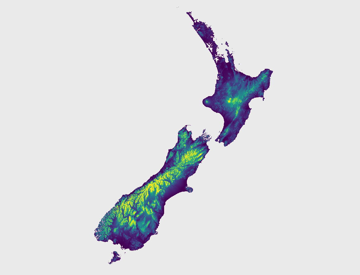
New Zealand: LINZ DEMs & Related
LINZ provides a collection of DEMs for different regions of New Zealand. The resolution is 1m.
There also exist lower resolution processings of the LINZ datasets.
Links
- LINZ 1m DEMs
- NZ DEM (8m), derived from 20m contours on LINZ topo map
- NZDEM-HGT-30 in HGT/SRTM1 format with 1 arc-second resolution.
Non-terrestrial, open
Lunar Orbiter Laser Altimeter (LOLA)
Lunar DEM created by the Lunar Reconnaissance Orbiter (LRO) mission. The data is available in several versions. A DEM covering the entire lunar surface at a resolution of 118m and a DEM of resolution 59m covering latitudes within ±60.

Links
Pluto New Horizon
A partial DEM of Pluto with a resolution of 300m

Links
Mars Orbiter Laser Altimeter (MOLA)
A DEM of Mars with a resolution of 463m

Links
Charon New Horizon
A partial DEM of Pluto with a resolution of 300m

Links
Mercury Messenger
A DEM of Mercury with a resolution of 665m

Links
Venus Magellan
A Dem of Venus with a resolution of 4641m

Links
- Logo created with Brandmark
Owner
- Name: Daniel Jahn (dahn)
- Login: DahnJ
- Kind: user
- Location: null island (epsg:3068)
- Company: @SylveraIO
- Twitter: dahnjahn
- Repositories: 5
- Profile: https://github.com/DahnJ
If it has coordinates, then I'm up for it
Citation (CITATION.cff)
cff-version: 1.2.0
message: "If you want to reference this repository, please cite it as below."
preferred-citation:
  type: generic
  authors:
  - family-names: "Jahn"
    given-names: "Daniel"
  title: "Awesome DEM"
  url: "https://github.com/DahnJ/Awesome-DEM"
GitHub Events
Total
- Watch event: 50
- Fork event: 5
Last Year
- Watch event: 50
- Fork event: 5
Committers
Last synced: about 1 year ago
Top Committers
| Name | Commits | |
|---|---|---|
| DahnJ | d****n@g****m | 32 |
| MBunel | M****l | 7 |
| gangerang | 8****g | 4 |
| Xavier Fischer | x****r | 2 |
| utagawal | 1****l | 1 |
| Nikolay Korotkiy | s****r@d****g | 1 |
| Michael Schmuki | b****d | 1 |
Committer Domains (Top 20 + Academic)
Issues and Pull Requests
Last synced: about 1 year ago
All Time
- Total issues: 8
- Total pull requests: 8
- Average time to close issues: 26 days
- Average time to close pull requests: 3 days
- Total issue authors: 8
- Total pull request authors: 6
- Average comments per issue: 0.75
- Average comments per pull request: 1.13
- Merged pull requests: 8
- Bot issues: 0
- Bot pull requests: 0
Past Year
- Issues: 1
- Pull requests: 1
- Average time to close issues: N/A
- Average time to close pull requests: 10 minutes
- Issue authors: 1
- Pull request authors: 1
- Average comments per issue: 0.0
- Average comments per pull request: 1.0
- Merged pull requests: 1
- Bot issues: 0
- Bot pull requests: 0
Top Authors
Issue Authors
- mvl22 (1)
- fallaciousreasoning (1)
- CarlosGrohmann (1)
- cesierras (1)
- mhaberler (1)
- ThomasG77 (1)
- robmarkcole (1)
Pull Request Authors
- sikmir (2)
- xfischer (2)
- MBunel (2)
- gangerang (1)
- boardend (1)
- utagawal (1)