https://github.com/anerv/nerds_osmnx
OSMnx: Python for street networks. Retrieve, model, analyze, and visualize street networks and other spatial data from OpenStreetMap.
Science Score: 13.0%
This score indicates how likely this project is to be science-related based on various indicators:
-
○CITATION.cff file
-
○codemeta.json file
-
○.zenodo.json file
-
✓DOI references
Found 1 DOI reference(s) in README -
○Academic publication links
-
○Academic email domains
-
○Institutional organization owner
-
○JOSS paper metadata
-
○Scientific vocabulary similarity
Low similarity (15.0%) to scientific vocabulary
Last synced: 9 months ago
·
JSON representation
Repository
OSMnx: Python for street networks. Retrieve, model, analyze, and visualize street networks and other spatial data from OpenStreetMap.
Basic Info
- Host: GitHub
- Owner: anerv
- License: mit
- Language: Jupyter Notebook
- Default Branch: main
- Homepage: https://geoffboeing.com/publications/osmnx-complex-street-networks/
- Size: 11.5 MB
Statistics
- Stars: 3
- Watchers: 0
- Forks: 1
- Open Issues: 0
- Releases: 0
Fork of gboeing/osmnx
Created over 4 years ago
· Last pushed over 3 years ago
https://github.com/anerv/NERDS_osmnx/blob/main/
# Modified version of OSMnx Simplification **OSMnx** is a Python package that lets you download geospatial data from OpenStreetMap and model, project, visualize, and analyze real-world street networks and any other geospatial geometries. You can download and model walkable, drivable, or bikeable urban networks with a single line of Python code then easily analyze and visualize them. You can just as easily download and work with other infrastructure types, amenities/points of interest, building footprints, elevation data, street bearings/orientations, and speed/travel time. If you use OSMnx in your work, please cite the journal article. **Citation info**: Boeing, G. 2017. "[OSMnx: New Methods for Acquiring, Constructing, Analyzing, and Visualizing Complex Street Networks](https://geoffboeing.com/publications/osmnx-complex-street-networks/)." *Computers, Environment and Urban Systems* 65, 126-139. doi:10.1016/j.compenvurbsys.2017.05.004 ## Changes to OSMnx Changes made by Clment Sebastiao with the help of Ane Rahbek Vier and Anastassia Vybornova. Based on the osmnx.simplification.simplify_graph function of **OSMnx**, we want to adapt it in such a way that it can avoid to simplify nodes where an attribute ( from an arbitrary list of attributes optionally given as an input) differ between the edges. To use network theory terminology, this is a way to generalize the function to multilayer graph. It allows us to simplify **OpenStreetMap** datafile while keeping the informations on the attributes we want to look at, for instance to discriminate between primary and secondary highway, or lane with and without bicycle path, information that is lost otherwise with the function from **OSMnx**. After such simplification where we remove unnecessary (because we don't loose information without them) interstitional (because they are between other nodes) nodes, we want to independently be able to simplify the structure of the network while loosing as less as possible information : * Go from a directed multigraph to a directed graph by avoiding multiple edges and getting rid of the more theoretical edges that are added to represent traffic on both directions. In order to do this, we will need to create unnecessary interstitional nodes so that there is no self-loop or mutliple path between two nodes. * Go from a directed graph to an undirected graph This step helps us to manipulate the network afterwards, for instance to use metrics that works only on graph such as betweenness centrality. 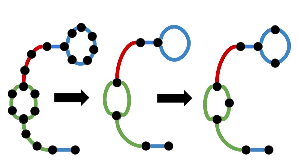 ## To add as a local package Based on the [The Good Research Code Handbook](https://goodresearch.dev/setup.html#pip-install-your-package), you should: * Put yourself on your virtual environment and on the folder, such as /NERDS_osmnx * Run pip install -e . ". indicates that were installing the package in the current directory. -e indicates that the package should be editable. That means that if you change the files inside the [source] folder, you dont need to re-install the package for your changes to be picked up by Python." ## Note on requirements.txt and environment.yml The requirements.txt is made with the full list of packages using the command line "conda list --export > requirements.txt", thus a lot of packages installed with it may not be necessary in order to run the code. The environment.yml file was made manually, installing only the packages specified on the python scripts.
Owner
- Name: Ane R V
- Login: anerv
- Kind: user
- Location: Cph
- Company: ITU
- Twitter: _ane_rv
- Repositories: 4
- Profile: https://github.com/anerv
PhD student at NERDS, ITU Copenhagen Geospatial Data Science // Mobility // Urban Data