https://github.com/carlos-alberto-silva/helios
HELIOS - the Heidelberg LiDAR Operations Simulator - is a software package for interactive real-time simulation and visualisation of terrestrial, mobile and airborne laser scan surveys written in Java.
Science Score: 23.0%
This score indicates how likely this project is to be science-related based on various indicators:
-
○CITATION.cff file
-
○codemeta.json file
-
○.zenodo.json file
-
✓DOI references
Found 29 DOI reference(s) in README -
○Academic publication links
-
✓Committers with academic emails
6 of 14 committers (42.9%) from academic institutions -
○Institutional organization owner
-
○JOSS paper metadata
-
○Scientific vocabulary similarity
Low similarity (18.8%) to scientific vocabulary
Keywords from Contributors
Repository
HELIOS - the Heidelberg LiDAR Operations Simulator - is a software package for interactive real-time simulation and visualisation of terrestrial, mobile and airborne laser scan surveys written in Java.
Basic Info
- Host: GitHub
- Owner: carlos-alberto-silva
- License: gpl-3.0
- Default Branch: master
- Homepage: http://www.geog.uni-heidelberg.de/gis/helios.html
- Size: 65.6 MB
Statistics
- Stars: 2
- Watchers: 1
- Forks: 0
- Open Issues: 0
- Releases: 0
Metadata Files
README.md
HELIOS
Heidelberg LiDAR Operations Simulator (HELIOS)
HELIOS is a software package for interactive real-time simulation and visualization of terrestrial, mobile and airborne laser scanning surveys written in Java. Official website: https://www.uni-heidelberg.de/helios
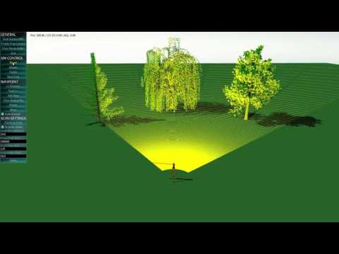
Table of Contents
Install
The pre-built project is available here with a test scene and survey. Note that for faster simulations building the project is recommended.
To build the project, first install the dependencies, then compile the source code, and finally execute it.
Requisites
- Oracle Java 1.8
- Maven 3
You can use java -version and mvn -v to check if you already have installed those on your computer.
Linux/Ubuntu:
They can be installed by:
bash
sudo apt-get install oracle-java8-installer maven
Windows:
In Windows installation is less straightforward:
- Java JDK
1. Download the Java JDK 8 and install it
2. Create the environment variable JAVA_HOME to point to the JDK folder
(e .g: JAVAHOME=C:\Program Files\Java\jdk1.8.0151)
3. Add to the PATH the value %JAVA_HOME%\bin
- Maven
1. Download the Maven binary zip
2. Unzip it and move it to the desired folder (e. g. C:\apache-maven-3.5.2)
3. Add to the PATH the bin folder inside (e. g. C:\apache-maven-3.5.2\bin)
Compilation
Download the source code from this web site or from git:
bash
git clone https://github.com/GIScience/helios.git
Then inside the root folder simply execute:
bash
mvn package
Eclipse IDE
To add this project to Eclipse go to File > Import > Existing Maven Projects and select helios folder.
You may also want to disable the spell checker: right click in the project > Checkstyle > Deactivate Checkstyle
Usage
HELIOS supports both single-ray and full-waveform simulations. Currently the default mode is the full-waveform. The selection between this two methods is done in the source code when creating the detector object in XmlAssetsLoader.java.
Input
The argument of the program is the survey XML file, also the 3D models of the scene pointed in the survey are needed. See Wiki: Basic input data for further details.
This Blender addon can be used to convert Blender scenes to HELIOS scenes.
Execution
From the root folder run:
bash
java -jar target/helios.jar <survey-file>
To run the example survey:
bash
java -jar target/helios.jar data/surveys/demo/tls_arbaro_demo.xml
To use the batch mode (no visualization):
bash
java -jar target/helios.jar <survey-file> headless
Output
Output files are generated inside output/Survey Playback folder.
- Point cloud: File named legxxx_points.xyz separated by spaces where xxx is the leg number.
Fields:
X Y Z I ECHOWIDTH RN NOR FWFID OBJ_ID
Example:
-4.615 15.979 2.179 4.0393 1.4317 1 1 214275 1 - Waveform: File named legxxx_points.xyzfullwave.txt separated by spaces where xxx is the leg number.
See FWF.md for further details.
Documentation
See Wiki.
Research using HELIOS
Zhu, X., Liu, J., Skidmore, A.K., Premier, J., Heurich, M. (2020): A voxel matching method for effective leaf area index estimation in temperate deciduous forests from leaf-on and leaf-off airborne LiDAR data. In: Remote Sensing of Environment, 240. DOI: 10.1016/j.rse.2020.111696.
Lin, C.-H. & Wang, C.-K. (2019): Point Density Simulation for ALS Survey. In: Proceedings of the 11th International Conference on Mobile Mapping Technology (MMT2019), Shenzhen, China. pp. 157-160.
Liu, J., Skidmore, A.K., Wang, T., Zhu, X., Premier, J., Heurich, M., Beudert, B. & Jones, S. (2019): Variation of leaf angle distribution quantified by terrestrial LiDAR in natural European beech forest. In: ISPRS Journal of Photogrammetry and Remote Sensing, 148, pp. 208-220. DOI: 10.1016/j.isprsjprs.2019.01.005.
Liu, J., Wang, T., Skidmore, A.K., Jones, S., Heurich, M., Beudert, B. & Premier, J. (2019): Comparison of terrestrial LiDAR and digital hemispherical photography for estimating leaf angle distribution in European broadleaf beech forests. In: ISPRS Journal of Photogrammetry and Remote Sensing, 158, pp. 76-89. DOI: 10.1016/j.isprsjprs.2019.09.015.
Martínez Sánchez, J., Váquez Álvarez, Á., López Vilariño, D., Fernández Rivera, F., Cabaleiro Domínguez, J.C., Fernández Pena, T. (2019): Fast Ground Filtering of Airborne LiDAR Data Based on Iterative Scan-Line Spline Interpolation. In: Remote Sensing, 11(19), pp. 23 (2256). DOI: 10.3390/rs11192256.
Previtali, M., Díaz-Vilariño, L., Scaioni, M. & Frías Nores, E. (2019): Evaluation of the Expected Data Quality in Laser Scanning Surveying of Archaeological Sites. In: 4th International Conference on Metrology for Archaeology and Cultural Heritage, Florence, Italy, 4-6 December 2019, pp. 19-24.
Xiao, W., Zaforemska, A., Smigaj, M., Wang, Y. & Gaulton, R. (2019): Mean Shift Segmentation Assessment for Individual Forest Tree Delineation from Airborne Lidar Data. In: Remote Sensing, 11(11), pp. 19 (1263). DOI: 10.3390/rs11111263.
Zhang, Z., Li, J., Guo, Y., Yang, C., & Wang, C. (2019): 3D Highway Curve Reconstruction From Mobile Laser Scanning Point Clouds. In: IEEE Transactions on Intelligent Transportation Systems. DOI: 10.1109/TITS.2019.2946259.
Hämmerle, M., Lukač, N., Chen, K.-C., Koma, Zs., Wang, C.-K., Anders, K., & Höfle, B. (2017): Simulating Various Terrestrial and UAV LiDAR Scanning Configurations for Understory Forest Structure Modelling. In: ISPRS Ann. Photogramm. Remote Sens. Spatial Inf. Sci., IV-2/W4, pp. 59-65. DOI: 10.5194/isprs-annals-IV-2-W4-59-2017.
Rebolj, D., Pučko, Z., Babič, N.Č., Bizjak, M. & Mongus, D. (2017). Point cloud quality requirements for Scan-vs-BIM based automated construction progress monitoring. In: Automation in Construction, 84, pp. 323-334. DOI: 10.1016/j.autcon.2017.09.021.
Bechtold, S., Hämmerle, M. & Höfle, B. (2016): Simulated full-waveform laser scanning of outcrops for development of point cloud analysis algorithms and survey planning: An application for the HELIOS lidar simulation framework. In: Proceedings of the 2nd Virtual Geoscience Conference, Bergen, Norway, 21-23 September 2016, pp 57-58.
Authorship
3DGeo Research Group
Institute of Geography
Heidelberg University
http://www.uni-heidelberg.de/3dgeo
Citation
Bechtold, S. & Höfle, B. (2016): HELIOS: A Multi-Purpose LiDAR Simulation Framework for Research, Planning and Training of Laser Scanning Operations with Airborne, Ground-Based Mobile and Stationary Platforms. ISPRS Annals of Photogrammetry, Remote Sensing and Spatial Information Sciences. Vol. III-3, pp. 161-168. DOI: 10.5194/isprs-annals-III-3-161-2016
If you use HELIOS in your work, please cite:
@Article{isprs-annals-III-3-161-2016,
AUTHOR = {Bechtold, S. and H\"ofle, B.},
TITLE = {{HELIOS}: A Multi-Purpose LiDAR Simulation Framework for Research, Planning and Training of Laser Scanning Operations with Airborne, Ground-Based Mobile and Stationary Platforms},
JOURNAL = {ISPRS Annals of Photogrammetry, Remote Sensing and Spatial Information Sciences},
VOLUME = {III-3},
YEAR = {2016},
PAGES = {161--168},
URL = {https://www.isprs-ann-photogramm-remote-sens-spatial-inf-sci.net/III-3/161/2016/},
DOI = {10.5194/isprs-annals-III-3-161-2016}
}
We are happy if you are using HELIOS in your work - let us know!
Maintainers
@sebastian-bechtold @nlukac @kathapand @deuxbot @lrg-bhoefle
The first HELIOS version with full-waveform support is available in this repository maintained by @nlukac.
License
See LICENSE.md.
Owner
- Name: Carlos Alberto Silva
- Login: carlos-alberto-silva
- Kind: user
- Company: University of Florida
- Website: https://carlos-alberto-silva.github.io/silvalab/home.html
- Twitter: Web_LiDAR
- Repositories: 100
- Profile: https://github.com/carlos-alberto-silva
GitHub Events
Total
Last Year
Committers
Last synced: over 2 years ago
Top Committers
| Name | Commits | |
|---|---|---|
| katharina | k****s@u****e | 17 |
| Sebastian Bechtold | s****d@s****e | 14 |
| martinez | m****z@g****9 | 9 |
| KoeMai | g****b@m****e | 8 |
| MartinPetitMarteau | h****e@u****e | 5 |
| Jorge Martínez Sánchez | j****z@u****s | 5 |
| katharina | k****s@s****e | 5 |
| sebastian-bechtold | m****d@g****m | 4 |
| m1st4x | 5****x | 4 |
| katharina | 3****d | 3 |
| Jorge Martínez | d****t | 2 |
| Anders | 9****s@a****e | 1 |
| sbecht | s****t | 1 |
| lrg-bhoefle | h****e@u****e | 1 |
Committer Domains (Top 20 + Academic)
Issues and Pull Requests
Last synced: over 2 years ago
All Time
- Total issues: 0
- Total pull requests: 0
- Average time to close issues: N/A
- Average time to close pull requests: N/A
- Total issue authors: 0
- Total pull request authors: 0
- Average comments per issue: 0
- Average comments per pull request: 0
- Merged pull requests: 0
- Bot issues: 0
- Bot pull requests: 0
Past Year
- Issues: 0
- Pull requests: 0
- Average time to close issues: N/A
- Average time to close pull requests: N/A
- Issue authors: 0
- Pull request authors: 0
- Average comments per issue: 0
- Average comments per pull request: 0
- Merged pull requests: 0
- Bot issues: 0
- Bot pull requests: 0
Top Authors
Issue Authors
Pull Request Authors
Top Labels
Issue Labels
Pull Request Labels
Dependencies
- gov.nist.math:jama 1.0.3 compile
- com.google.guava:guava 19.0
- com.simsilica:lemur 1.9.1
- commons-validator:commons-validator 1.4.0
- org.apache.commons:commons-math3 3.4.1
- org.codehaus.groovy:groovy-all 2.1.9
- org.geotools:gt-epsg-extension 13.0
- org.geotools:gt-epsg-hsql 13.0
- org.geotools:gt-geotiff 13.0
- org.geotools:gt-image 13.0
- org.geotools:gt-referencing 13.0
- org.geotools:gt-wms 13.0
- org.jmonkeyengine:jme3-core 3.1.0-beta1
- org.jmonkeyengine:jme3-desktop 3.1.0-beta1
- org.jmonkeyengine:jme3-lwjgl 3.1.0-beta1
- org.orangepalantir:leastsquares 1.0.0
- org.slf4j:slf4j-api 1.7.21
- junit:junit 3.8.1 test
- junit:junit 4.8.2 test