Science Score: 49.0%
This score indicates how likely this project is to be science-related based on various indicators:
-
○CITATION.cff file
-
✓codemeta.json file
Found codemeta.json file -
✓.zenodo.json file
Found .zenodo.json file -
✓DOI references
Found 12 DOI reference(s) in README -
✓Academic publication links
Links to: joss.theoj.org, zenodo.org -
○Academic email domains
-
○Institutional organization owner
-
○JOSS paper metadata
-
○Scientific vocabulary similarity
Low similarity (14.0%) to scientific vocabulary
Repository
Basic Info
- Host: GitHub
- Owner: nicorag
- License: lgpl-3.0
- Language: Python
- Default Branch: main
- Size: 797 MB
Statistics
- Stars: 0
- Watchers: 1
- Forks: 0
- Open Issues: 0
- Releases: 0
Metadata Files
README.md
 > Spatial data and information processing for geomodeling
[](https://www.python.org/downloads/)


[](https://mybinder.org/v2/gh/cgre-aachen/gemgis/main)

[](https://doi.org/10.21105/joss.03709)
[](https://doi.org/10.5281/zenodo.6511767)
[](https://doi.org/10.5194/egusphere-egu21-4613)
> Spatial data and information processing for geomodeling
[](https://www.python.org/downloads/)


[](https://mybinder.org/v2/gh/cgre-aachen/gemgis/main)

[](https://doi.org/10.21105/joss.03709)
[](https://doi.org/10.5281/zenodo.6511767)
[](https://doi.org/10.5194/egusphere-egu21-4613)
Overview
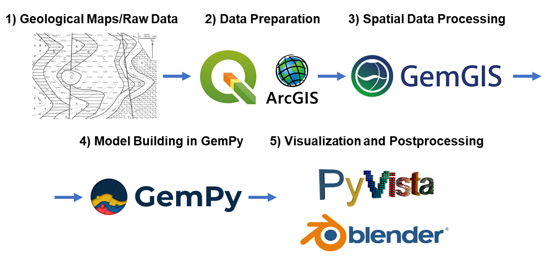
We attempt to simplify the access to open-source spatial data processing for geological modeling with the development of GemGIS, a Python-based open-source library.
GemGIS wraps and extends the functionality of packages known to the geo-community such as GeoPandas, rasterio, OWSLib, Shapely, PyGEOS, PyVista, Pandas, NumPy and the geomodeling package GemPy.
The aim of GemGIS, as indicated by the name, is to become a bridge between conventional geoinformation systems (GIS) such as ArcGIS and QGIS, and geomodeling tools such as GemPy, allowing simpler and more automated workflows from one environment to the other. This also includes making it simpler to visualize the results obtained from GemGIS and GemPy with PyVista or Blender.
Resources
Find the documentation of GemGIS here. It includes introductions to the main libraries used and to introductory topics like "What is vector data?" or "What is raster data?".
In addition, tutorial notebooks provide an overview of the different features of GemGIS. The notebooks can also be downloaded directly from here. Furthermore, many example models showcase a variety of geological structures that can be modeled with GemGIS and GemPy.
Installation
It is recommended to use GemGIS with python==3.9 in a separated environment. The main packages and its dependencies can be installed via the conda-forge channel. GemGIS is then available through PyPi.
1) conda install -c conda-forge pygeos
2) conda install -c conda-forge geopandas
3) conda install -c conda-forge rasterio
4) conda install -c conda-forge pyvista
5) pip install gemgis / conda install -c conda-forge gemgis
Check out the Installation Page for more detailed instructions.
Contribution Guidelines
The Contribution Guidelines for GemGIS can be found here: Contribution Guidelines
We welcome issue reports, questions, ideas for new features and pull-requests to fix issues or even add new features to the software. Once a pull-request is opened, we will guide through the review process.
References
- Jstel, A., Endlein Correira, A., Wellmann, F. and Pischke, M.: GemGIS GemPy Geographic: Open-Source Spatial Data Processing for Geological Modeling. EGU General Assembly 2021, https://doi.org/10.5194/egusphere-egu21-4613, 2021
- Jstel, A.: 3D Probabilistic Modeling and Data Analysis of the Aachen-Weisweiler Area: Implications for Deep Geothermal Energy Exploration, unpublished Master Thesis at RWTH Aachen University, 2020
- de la Varga, M., Schaaf, A., and Wellmann, F.: GemPy 1.0: open-source stochastic geological modeling and inversion, Geosci. Model Dev., 12, 1-32, https://doi.org/10.5194/gmd-12-1-2019, 2019
- Powell, D.: Interpretation of Geological Structures Through Maps: An Introductory Practical Manual, Longman, pp. 192, 1992
- Bennison, G.M.: An Introduction to Geological Structures and Maps, Hodder Education Publication, pp. 78, 1990
Owner
- Name: Guillermo Nicora
- Login: nicorag
- Kind: user
- Location: La Plata, Argentina
- Company: Servicio de Hidrografía Naval
- Repositories: 21
- Profile: https://github.com/nicorag
I'm geophysicist, and try to learn more about Geology, Oceanography, Data Science, Machine Learning... Another topics of interest to me are chess and finance
GitHub Events
Total
Last Year
Issues and Pull Requests
Last synced: about 2 years ago
All Time
- Total issues: 0
- Total pull requests: 0
- Average time to close issues: N/A
- Average time to close pull requests: N/A
- Total issue authors: 0
- Total pull request authors: 0
- Average comments per issue: 0
- Average comments per pull request: 0
- Merged pull requests: 0
- Bot issues: 0
- Bot pull requests: 0
Past Year
- Issues: 0
- Pull requests: 0
- Average time to close issues: N/A
- Average time to close pull requests: N/A
- Issue authors: 0
- Pull request authors: 0
- Average comments per issue: 0
- Average comments per pull request: 0
- Merged pull requests: 0
- Bot issues: 0
- Bot pull requests: 0
Top Authors
Issue Authors
Pull Request Authors
Top Labels
Issue Labels
Pull Request Labels
Dependencies
- actions/checkout v2 composite
- actions/upload-artifact v1 composite
- openjournals/openjournals-draft-action master composite
- actions/first-interaction v1 composite
- actions/checkout v2 composite
- actions/setup-python v2 composite
- actions/checkout v2 composite
- conda-incubator/setup-miniconda v2 composite
- gemgis *
- geopandas =0.9
- pygeos =0.9
- pyvista =0.29
- rasterio =1.2.1
- nbsphinx * development
- numpy * development
- numpydoc >=0.9 development
- pandas * development
- pooch <1.5.0 development
- pypandoc * development
- pytest * development
- rasterio * development
- sphinx >3 development
- sphinx_automodapi * development
- sphinx_copybutton * development
- sphinx_gallery * development
- sphinx_markdown_tables * development
- sphinx_numfig * development
- sphinx_rtd_theme * development
- twine * development
- PyPDF2 *
- affine *
- gempy *
- geopy *
- matplotlib *
- mplstereonet *
- numpy *
- owslib *
- pandas *
- pooch <1.5.0
- pyqt5 *
- pytest *
- pytest-cov *
- rioxarray *
- scikit-image *
- scikit-learn *
- scipy *
- shapely *
- tqdm *
- xmltodict *