Science Score: 67.0%
This score indicates how likely this project is to be science-related based on various indicators:
-
✓CITATION.cff file
Found CITATION.cff file -
✓codemeta.json file
Found codemeta.json file -
✓.zenodo.json file
Found .zenodo.json file -
✓DOI references
Found 8 DOI reference(s) in README -
✓Academic publication links
Links to: nature.com -
○Committers with academic emails
-
○Institutional organization owner
-
○JOSS paper metadata
-
○Scientific vocabulary similarity
Low similarity (11.9%) to scientific vocabulary
Keywords
Repository
🛰️ Process raster data in python
Basic Info
- Host: GitHub
- Owner: spaceml-org
- License: lgpl-3.0
- Language: Jupyter Notebook
- Default Branch: main
- Homepage: https://spaceml-org.github.io/georeader
- Size: 201 MB
Statistics
- Stars: 23
- Watchers: 3
- Forks: 7
- Open Issues: 1
- Releases: 19
Topics
Metadata Files
README.md


 georeader
georeader is a package to process raster data from different satellite missions. georeader makes easy to read specific areas of your image, to reproject images from different satellites to a common grid (georeader.read), to go from vector to raster formats (georeader.vectorize and georeader.rasterize) or to do radiance to reflectance conversions (georeader.reflectance).
georeader is mainly used to process satellite data for scientific usage, to create ML-ready datasets and to implement end-to-end operational inference pipelines (e.g. the Kherson Dam Break floodmap).
Install
The core package dependencies are numpy, rasterio, shapely and geopandas.
bash
pip install georeader-spaceml
Getting started
Read from a Sentinel-2 image a fixed size subimage on an specific
lon,latlocation (directly from the S2 public Google Cloud bucket):
```python
This snippet requires:
pip install fsspec gcsfs google-cloud-storage
import os os.environ["GSNOSIGN_REQUEST"] = "YES"
from georeader.readers import S2SAFEreader from georeader import read
cordsread = (-104.394, 32.026) # long, lat crscords = "EPSG:4326" s2safepath = S2SAFEreader.s2publicbucketpath("S2BMSIL1C20191008T173219N0208R055T13SER20191008T204555.SAFE") s2obj = S2SAFEreader.s2loader(s2safepath, outres=10, bands=["B04","B03","B02"])
copy to local avoids http errors specially when not using a Google Cloud project.
This will only copy the bands set up above B04, B03 and B02
s2obj = s2obj.cacheproducttolocaldir(".")
See also read.readfrombounds, read.readfrompolygon for different ways of croping an image
data = read.readfromcentercoords(s2obj,cordsread, shape=(2040, 4040), crscentercoords=crs_cords)
data_memory = data.load() # this loads the data to memory
data_memory # GeoTensor object
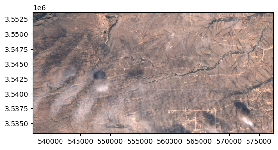
Transform: | 10.00, 0.00, 537020.00| | 0.00,-10.00, 3553680.00| | 0.00, 0.00, 1.00| Shape: (3, 2040, 4040) Resolution: (10.0, 10.0) Bounds: (537020.0, 3533280.0, 577420.0, 3553680.0) CRS: EPSG:32613 fillvaluedefault: 0 ```
In the .values attribute we have the plain numpy array that we can plot with show:
```python from rasterio.plot import show show(datamemory.values/3500, transform=datamemory.transform)
```
Saving the GeoTensor as a COG GeoTIFF:
```python from georeader.save import save_cog
Supports writing in bucket location (e.g. gs://bucket-name/s2_crop.tif)
savecog(datamemory, "s2_crop.tif", descriptions=s2obj.bands) ```
Tutorials
Sentinel-2
- Reading Sentinel-2 images from the public Google bucket

- Tiling and stitching predictions of an AI model
- Explore metadata of Sentinel-2 object
- Query Sentinel-2 images over a location and time span, mosaic and plot them
- Sentinel-2 images from GEE and CloudSEN12 cloud detection
Read rasters from different satellites
- Tutorial to read overlapping tiles from a GeoTIFF and a Sentinel-2 image
- Example of reading a Proba-V image overlapping with Sentinel-2 forcing same resolution
- Work with EMIT images
- Read overlapping images of PRISMA and EMIT
- Read EnMAP images, integrate them to Sentinel-2 bands, convert radiance to TOA reflectance and run CloudSEN12 cloud detection model
Used in other projects
- georeader with ml4floods to automatically download and produce flood extent maps: the Kherson Dam Break example
- georeader with STARCOP to simulate Sentinel-2 from AVIRIS images
- georeader with STARCOP to run plume detection in EMIT images
- georeader with CloudSEN12 to run cloud detection in Sentinel-2 images
Citation
If you find this code useful please cite:
@article{portales-julia_global_2023,
    title = {Global flood extent segmentation in optical satellite images},
    volume = {13},
    issn = {2045-2322},
    doi = {10.1038/s41598-023-47595-7},
    number = {1},
    urldate = {2023-11-30},
    journal = {Scientific Reports},
    author = {Portalés-Julià, Enrique and Mateo-García, Gonzalo and Purcell, Cormac and Gómez-Chova, Luis},
    month = nov,
    year = {2023},
    pages = {20316},
}
@article{ruzicka_starcop_2023,
    title = {Semantic segmentation of methane plumes with hyperspectral machine learning models},
    volume = {13},
    issn = {2045-2322},
    url = {https://www.nature.com/articles/s41598-023-44918-6},
    doi = {10.1038/s41598-023-44918-6},
    number = {1},
    journal = {Scientific Reports},
    author = {Růžička, Vít and Mateo-Garcia, Gonzalo and Gómez-Chova, Luis and Vaughan, Anna, and Guanter, Luis and Markham, Andrew},
    month = nov,
    year = {2023},
    pages = {19999},
}
Acknowledgments
This research has been supported by the DEEPCLOUD project (PID2019-109026RB-I00) funded by the Spanish Ministry of Science and Innovation (MCIN/AEI/10.13039/501100011033) and the European Union (NextGenerationEU).
 funded by MCIN/AEI/10.13039/501100011033.")
Owner
- Name: SpaceML
- Login: spaceml-org
- Kind: organization
- Website: spaceml.org
- Repositories: 19
- Profile: https://github.com/spaceml-org
Citation (CITATION.cff)
cff-version: 1.2.0
message: "If you use this software, please cite it as below."
authors:
- family-names: "Mateo-Garcia"
  given-names: "Gonzalo"
  orcid: "https://orcid.org/0000-0002-0569-393X"
  affiliation: "Universitat de Valencia"
title: "georeader"
version: 1.0.9
doi: 10.1038/s41598-023-47595-7
date-released: 2022-11-01
url: "https://github.com/spaceml-org/georeader"
GitHub Events
Total
- Create event: 14
- Release event: 1
- Issues event: 1
- Watch event: 7
- Delete event: 7
- Member event: 1
- Issue comment event: 2
- Push event: 113
- Pull request review comment event: 5
- Pull request review event: 11
- Pull request event: 19
- Fork event: 3
Last Year
- Create event: 14
- Release event: 1
- Issues event: 1
- Watch event: 7
- Delete event: 7
- Member event: 1
- Issue comment event: 2
- Push event: 113
- Pull request review comment event: 5
- Pull request review event: 11
- Pull request event: 19
- Fork event: 3
Committers
Last synced: over 2 years ago
Top Committers
| Name | Commits | |
|---|---|---|
| Gonzalo Mateo | g****8@g****m | 174 |
| Gonzalo Mateo Garcia | g****a@u****g | 75 |
Committer Domains (Top 20 + Academic)
Issues and Pull Requests
Last synced: 11 months ago
All Time
- Total issues: 2
- Total pull requests: 28
- Average time to close issues: 3 months
- Average time to close pull requests: 7 days
- Total issue authors: 2
- Total pull request authors: 5
- Average comments per issue: 0.0
- Average comments per pull request: 0.07
- Merged pull requests: 25
- Bot issues: 0
- Bot pull requests: 0
Past Year
- Issues: 1
- Pull requests: 18
- Average time to close issues: N/A
- Average time to close pull requests: 6 days
- Issue authors: 1
- Pull request authors: 3
- Average comments per issue: 0.0
- Average comments per pull request: 0.06
- Merged pull requests: 16
- Bot issues: 0
- Bot pull requests: 0
Top Authors
Issue Authors
- giswqs (1)
Pull Request Authors
- gonzmg88 (26)
- montesinoman (3)
- giswqs (2)
- Muhammed0mer (2)
- jejjohnson (2)
Top Labels
Issue Labels
Pull Request Labels
Packages
- Total packages: 1
-
Total downloads:
- pypi 1,496 last-month
- Total dependent packages: 1
- Total dependent repositories: 0
- Total versions: 79
- Total maintainers: 1
pypi.org: georeader-spaceml
🛰️ Process raster data in python
- Homepage: https://github.com/spaceml-org/georeader
- Documentation: https://spaceml-org.github.io/georeader/
- License: LGPL-3.0
-
Latest release: 1.5.6
published 12 months ago
Rankings
Maintainers (1)
Dependencies
- numpy *
- rasterio *
- scikit-image *
- shapely *