gemgis-data
This repository contains the data used in GemGIS
Science Score: 67.0%
This score indicates how likely this project is to be science-related based on various indicators:
-
○CITATION.cff file
-
✓codemeta.json file
Found codemeta.json file -
✓.zenodo.json file
Found .zenodo.json file -
✓DOI references
Found 16 DOI reference(s) in README -
✓Academic publication links
Links to: joss.theoj.org -
✓Committers with academic emails
1 of 5 committers (20.0%) from academic institutions -
✓Institutional organization owner
Organization cgre-aachen has institutional domain (www.cgre.rwth-aachen.de) -
○JOSS paper metadata
-
○Scientific vocabulary similarity
Low similarity (12.8%) to scientific vocabulary
Keywords
Keywords from Contributors
Repository
This repository contains the data used in GemGIS
Basic Info
Statistics
- Stars: 4
- Watchers: 3
- Forks: 3
- Open Issues: 0
- Releases: 2
Topics
Metadata Files
README.md
 > Spatial data and information processing for geomodeling
[](https://www.python.org/downloads/)
[](https://pypi.org/project/gemgis_data/)

[](https://github.com/cgre-aachen/gemgis_data/blob/main/LICENSE)
[](https://gemgis.readthedocs.io/en/latest/index.html)
[](https://doi.org/10.21105/jose.00185)
> Spatial data and information processing for geomodeling
[](https://www.python.org/downloads/)
[](https://pypi.org/project/gemgis_data/)

[](https://github.com/cgre-aachen/gemgis_data/blob/main/LICENSE)
[](https://gemgis.readthedocs.io/en/latest/index.html)
[](https://doi.org/10.21105/jose.00185)
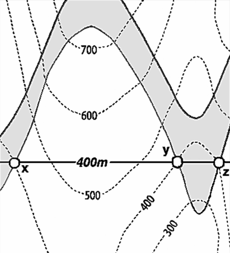
Source: Powell, D. (1995): Interpretation geologischer Strukturen durch Karten - Eine praktische Anleitung mit Aufgaben und Lsungen, page 15, figure 10 A, Springer Verlag Berlin, Heidelberg, New York, ISBN: 978-3-540-58607-4.
Overview
This repository provides the notebooks and data to the example models of GemGIS and GemPy. It is set up as course adapted from two Bachelor courses at RWTH Aachen University, Germany (Geological methods and geological map & Introduction to geological maps). The easiest way to access the data is to download the repository including all data from Github. The course contains the following sections:
- Introduction to the course
- Introduction to structural geological modeling using GemPy and GemGIS
- Introduction to structural geological models
- Introduction to GemPy and GemGIS
- Purpose of structural geological models in Earth Sciences
- Introduction to GemPy and GemGIS
- Resources for GemPy and GemGIS
- Installation of GemPy and GemGIS
- Modeling of the basic structures in GemPy
- Modeling of more complex models including additional tasks (main part)
- Post-processing of structural geological models using GemGIS
For more information about GemGIS and GemPy see the dedicated Github Repositories and Documentation pages: 1. GemPy 1. Github Repository 2. GemPy Documentation 3. GemPy Installation 4. GemPy Publication 5. Tutorial: Geological Modeling with GemPy @Transform 2020 6. Tutorial: Geological Modeling with GemPy @Transform 2021 7. Tutorial: Geological Modeling with GemPy
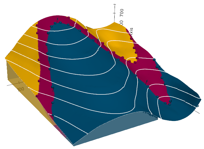
Purpose of structural geological models in Earth Sciences
Structural geological models describe the spatial distribution of layers in the subsurface. This includes the extent and depth distribution of either lithological layers (e.g. sand or clay, sandstones, carbonates, evaporites, etc.) or stratigraphic units for more regional questions of the structure of the subsurface (e.g. Base Tertiary, transition to basement rocks, etc.). The resulting structures can be used to parametrize the rocks between these constructed bounding surfaces for a wide range of applications. These include but are not limited to hydrogeological applications, geohazards, ressource extraction (e.g. fresh water, thermal waters, hydrocarbons, minerals), storage applications (e.g. thermal waters, gases such as CO2 or hydrogen, nuclear waste).
Target Audience
The tutorials provided in this repository aim at enabling students who want to become familiar with structural geological modeling in GemPy to have a smooth start. Further, the tutorials serve as aids for researchers to set up and parametrize their structural geological models properly. Lecturers are encouraged to use and adapt the provided tutorials for their own Python and Structural Geological Modeling classes.
Dependencies
The GemGIS package mainly depends on GeoPandas/Pandas, Rasterio and PyVista. All geometric operations are performed using Shapely. Numerical operations are performed using NumPy while plotting is done with Matplotlib. The structural modeling package GemPy is an optional dependency but is required to build the structural geological models.
The following dependency versions are recommended for using GemGIS (as of October 2025): - Python >=3.11 - GeoPandas >= 1.1.1 - Rasterio >= 1.4.3 - PyVista >= 0.46.3 - GemPy >= 2025.2.0
References and published articles utilizing GemGIS
- Jstel, A. et al.: 3D structural and probabilistic modelling of geothermal reservoir horizons in the Northern Eifel and its foreland. Zeitschrift der Deutschen Gesellschaft fr Geowissenschaften, 176 (1), 115-146, https://doi.org/10.1127/zdgg/2025/0436, 2025
- Marquetto, L. et al.: Developing a 3D hydrostratigraphical model of the emerged part of the Pelotas Basin along the northern coast of Rio Grande do Sul state, Brazil. Environmental Earth Sciences, 83, 10, 329, https://doi.org/10.1007/s12665-024-11609-y, 2024
- Jstel, A. et al.: From Maps to Models - Tutorials for structural geological modeling using GemPy and GemGIS. Journal of Open Source Education, 6(66), 185, https://doi.org/10.21105/jose.00185, 2023.
- Jstel, A. et al.: GemGIS - Spatial Data Processing for Geomodeling. Journal of Open Source Software, 7(73), 3709, https://doi.org/10.21105/joss.03709, 2022.
- Jstel, A., Endlein Correira, A., Wellmann, F. and Pischke, M.: GemGIS GemPy Geographic: Open-Source Spatial Data Processing for Geological Modeling. EGU General Assembly 2021, https://doi.org/10.5194/egusphere-egu21-4613, 2021.
- Jstel, A.: 3D Probabilistic Modeling and Data Analysis of the Aachen-Weisweiler Area: Implications for Deep Geothermal Energy Exploration, unpublished Master Thesis at RWTH Aachen University, 2020.
- de la Varga, M., Schaaf, A., and Wellmann, F.: GemPy 1.0: open-source stochastic geological modeling and inversion, Geosci. Model Dev., 12, 1-32, https://doi.org/10.5194/gmd-12-1-2019, 2019.
- Powell, D.: Interpretation of Geological Structures Through Maps: An Introductory Practical Manual, Longman, pp. 192, 1992.
- Bennison, G.M.: An Introduction to Geological Structures and Maps, Hodder Education Publication, pp. 78, 1990.
Owner
- Name: Computational Geoscience and Reservoir Engineering @RWTH Aachen
- Login: cgre-aachen
- Kind: organization
- Email: florian.wellmann@cgre.rwth-aachen.de
- Location: Aachen, Germany
- Website: https://www.cgre.rwth-aachen.de
- Repositories: 36
- Profile: https://github.com/cgre-aachen
We investigate novel methods to integrate geoscientific data and knowledge in process simulations of subsurface flow and transport problems.
GitHub Events
Total
- Issues event: 3
- Watch event: 1
- Push event: 1
- Fork event: 1
Last Year
- Issues event: 3
- Watch event: 1
- Push event: 1
- Fork event: 1
Committers
Last synced: over 2 years ago
Top Committers
| Name | Commits | |
|---|---|---|
| AlexanderJuestel | 4****l | 84 |
| Jüstel | a****l@i****e | 47 |
| AlexanderJuestel | a****l@g****m | 9 |
| Albert Krewinkel | a****t@z****e | 2 |
| Florian Wellmann | f****c@g****m | 1 |
Committer Domains (Top 20 + Academic)
Issues and Pull Requests
Last synced: 10 months ago
All Time
- Total issues: 10
- Total pull requests: 20
- Average time to close issues: about 1 year
- Average time to close pull requests: 2 days
- Total issue authors: 2
- Total pull request authors: 3
- Average comments per issue: 4.0
- Average comments per pull request: 0.05
- Merged pull requests: 19
- Bot issues: 0
- Bot pull requests: 0
Past Year
- Issues: 0
- Pull requests: 0
- Average time to close issues: N/A
- Average time to close pull requests: N/A
- Issue authors: 0
- Pull request authors: 0
- Average comments per issue: 0
- Average comments per pull request: 0
- Merged pull requests: 0
- Bot issues: 0
- Bot pull requests: 0
Top Authors
Issue Authors
- BenjMy (8)
- AlexanderJuestel (2)
Pull Request Authors
- AlexanderJuestel (18)
- BenjMy (1)
- tarleb (1)
Top Labels
Issue Labels
Pull Request Labels
Packages
- Total packages: 1
-
Total downloads:
- pypi 7 last-month
- Total dependent packages: 0
- Total dependent repositories: 0
- Total versions: 1
- Total maintainers: 1
pypi.org: gemgis-data
GemGIS is a Python-based, open-source spatial data processing library.
- Homepage: https://github.com/cgre-aachen/gemgis_data
- Documentation: https://gemgis-data.readthedocs.io/
- License: LGPL v3
-
Latest release: 0.0.2
published over 3 years ago
Rankings
Maintainers (1)
Dependencies
- actions/checkout v2 composite
- actions/upload-artifact v1 composite
- openjournals/openjournals-draft-action master composite
- actions/first-interaction v1 composite
- actions/checkout v2 composite
- actions/setup-python v2 composite
- geopandas >=0.12.2
- pyvista >=0.37.0
- rasterio >=1.3.4
- nbsphinx * development
- numpy * development
- numpydoc >=0.9 development
- pandas * development
- pooch <1.5.0 development
- pypandoc * development
- pytest * development
- rasterio * development
- sphinx >3 development
- sphinx_automodapi * development
- sphinx_copybutton * development
- sphinx_gallery * development
- sphinx_markdown_tables * development
- sphinx_numfig * development
- sphinx_rtd_theme * development
- twine * development