FIELDimageR
FIELDimageR: A R package to analyze orthomosaic images from agricultural field trials. This package is a compilation of functions to analyze pos-mosaicking images from research fields, and allows to: crop the image; remove soil effect; build vegetation indices; rotate the image; build the plot shapefile; extract information for each plot; and evaluate stand count, canopy percentage, and plant height.
Science Score: 36.0%
This score indicates how likely this project is to be science-related based on various indicators:
-
○CITATION.cff file
-
✓codemeta.json file
Found codemeta.json file -
○.zenodo.json file
-
✓DOI references
Found 8 DOI reference(s) in README -
○Academic publication links
-
✓Committers with academic emails
3 of 11 committers (27.3%) from academic institutions -
○Institutional organization owner
-
○JOSS paper metadata
-
○Scientific vocabulary similarity
Low similarity (13.7%) to scientific vocabulary
Keywords from Contributors
Repository
FIELDimageR: A R package to analyze orthomosaic images from agricultural field trials. This package is a compilation of functions to analyze pos-mosaicking images from research fields, and allows to: crop the image; remove soil effect; build vegetation indices; rotate the image; build the plot shapefile; extract information for each plot; and evaluate stand count, canopy percentage, and plant height.
Basic Info
Statistics
- Stars: 263
- Watchers: 41
- Forks: 93
- Open Issues: 28
- Releases: 0
Metadata Files
README.md
FIELDimageR: A Tool to Analyze Images From Agricultural Field Trials and Lab in R.
This package is a compilation of functions to analyze orthomosaic images from research fields. To prepare the image it first allows to crop the image, remove soil and weeds and rotate the image. The package also builds a plot shapefile in order to extract information for each plot to evaluate different wavelengths, vegetation indices, stand count, canopy percentage, and plant height.

Resources
2. Loading mosaics and visualizing
3. Removing soil using vegetation indices
4. Building the plot shapefile
5. Building vegetation indices
6. Counting the number of objects (e.g. plants, seeds, etc)
7. Evaluating the object area percentage (e.g. canopy)
8. Extracting data from field images
9. Estimating plant height (e.g., biomass) and creating interpolated mosaics based on sampled points
10. Distance between plants, objects length, and removing objects (plot, cloud, weed, etc.)
11. Resolution and computing time
13. Multispectral and Hyperspectral images
14. Building shapefile with polygons (field blocks, pest damage, soil differences, etc)
Orthomosaic using the open source software OpenDroneMap
Quick tips (memory limits, splitting shapefile, using shapefile from other software, etc)
Installation
If desired, one can build a rocker/rstudio based Docker image with all the requirements already installed by using the Dockerfile in this repository.
With RStudio
First of all, install R and RStudio. Then, in order to install R/FIELDimageR from GitHub GitHub repository, you need to install the following packages in R. For Windows users who have an R version higher than 4.0, you need to install RTools, tutorial RTools For Windows.
Now install R/FIELDimageR using the
install_githubfunction from devtools package. If necessary, use the argument type="source".
```r
You may need other packages first:
install.packages(c('terra','mapview','sf','stars','caret','mapedit','devtools',"dplyr","fields","leafem","leafsync","lwgeom","BiocManager","git2r","exactextractr")) BiocManager::install("EBImage")
FIELDimageR:
devtools::installgithub("OpenDroneMap/FIELDimageR") devtools::installgithub("filipematias23/FIELDimageR.Extra") ```
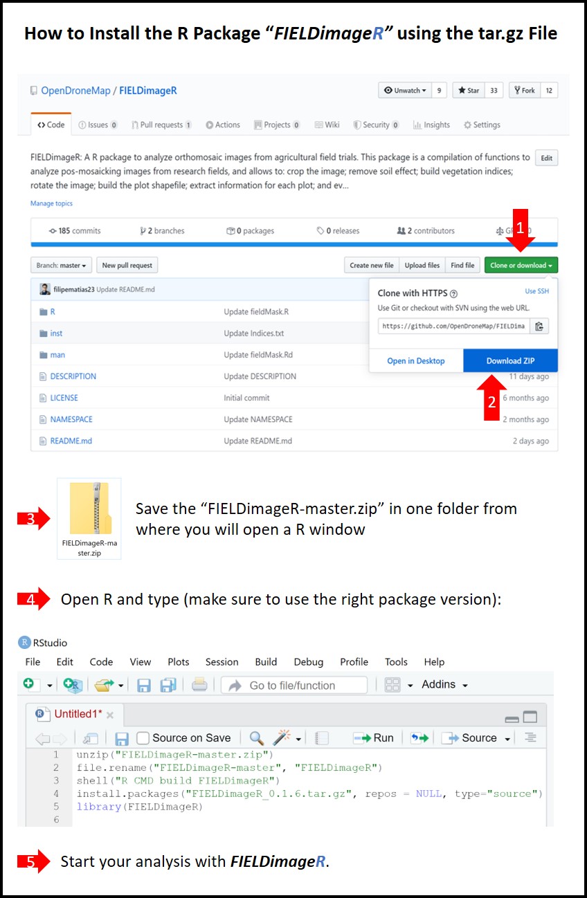
If the method above doesn't work, use the next lines by downloading the FIELDimageR-master.zip file
r
setwd("~/FIELDimageR-master.zip") # ~ is the path from where you saved the file.zip
unzip("FIELDimageR-master.zip")
file.rename("FIELDimageR-master", "FIELDimageR")
shell("R CMD build FIELDimageR") # or system("R CMD build FIELDimageR")
install.packages("FIELDimageR_0.6.0.tar.gz", repos = NULL, type="source") # Make sure to use the right version (e.g. 0.6.0)
With Docker
When building the Docker image you will need the Dockerfile in this repository available on the local machine. Another requirement is that Docker is installed on the machine as well.
Open a terminal window and at the command prompt enter the following command to build the Docker image:
bash
docker build -t fieldimager -f ./Dockerfile ./
The different command line parameters are as follows: *
dockeris the Docker command itself *buildtells Docker that we want to build an image *-tindicates that we will be specifying then tag (name) of the created image *fieldimageris the tag (name) of the image and can be any acceptable name; this needs to immediately follow the-tparameter *-findicates that we will be providing the name of the Dockerfile containing the instructions for building the image *./Dockerfileis the full path to the Dockerfile containing the instructions (in this case, it's in the current folder); this needs to immediately follow the-fparameter *./specifies that Docker build should use the current folder as needed (required by Docker build)The container includes a copy of RStudio Server and
tidyverse(see rocker/tidyverse). Alternatively, you can substituterocker/tidyversein the first line ofDockerfilewithrocker/rstudiofor a RStudio environment without thetidyversepackage.Once the docker image is built, you use the Docker run command to access the image using the suggested rocker/rstudio command:
bash
docker run --rm -p 8787:8787 -e PASSWORD=yourpasswordhere fieldimager
Open a web browser window and enter
http://localhost:8787to access the running container. To log into the instance use the username and password ofrstudioandyourpasswordhere.
If you are using anaconda and Linux
To install this package on Linux and anaconda it is necessary to use a series of commands before the recommendations
- Install Xorg dependencies for the plot system (on conda shell)
conda install -c conda-forge xorg-libx11
* Install the BiocManager package manager
r
install.packages("BiocManager")
- Use the BiocManager to install the EBIMAGE package
r
BiocManager::install("EBImage")
* If there is an error in the fftw3 library header (fftw3.h) install the dependency (on conda shell)
conda install -c eumetsat fftw3
- If there is an error in the dependency doParallel
r
install.packages ("doParallel")
- Continue installation
```r setwd("~/FIELDimageR-master.zip") # ~ is the path from where you saved the file.zip unzip("FIELDimageR-master.zip") file.rename("FIELDimageR-master", "FIELDimageR") system("R CMD build FIELDimageR") #only system works on linux install.packages("FIELDimageR_0.6.0.tar.gz", repos = NULL, type="source") # Make sure to use the right version (e.g. 0.6.0)
```
Using R/FIELDimageR
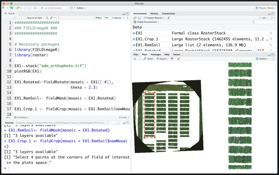
1. First steps
Taking the first step:
r
library(FIELDimageR)
library(FIELDimageR.Extra)
library(raster)
library(terra)
library(mapview)
library(sf)
library(stars)
Menu
2. Loading mosaics and visualizing
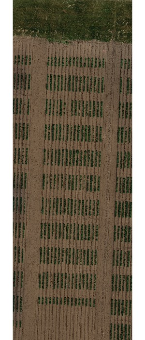
The following example uses an image available to download here: EX1_RGB.tif. If necessary, the image/mosaic size can be reduced around the field boundaries for faster image analysis using the function:
fieldCrop.
```r
Uploading an example mosaic
EX1 <- rast("EX1_RGB.tif")
Visualization Option-01 (FIELDimageR.Extra):
fieldView(EX1)
Visualization Option-02 (raster):
plotRGB(EX1, r = 1, g = 2, b = 3)
Only if necessary you can crop the mosaic/image to reduce size:
x11()
EX1 <- rast(fieldCrop(mosaic = EX1)) # For heavy images (large, high resolution, etc.) please use: fast.plot=T
```
```r
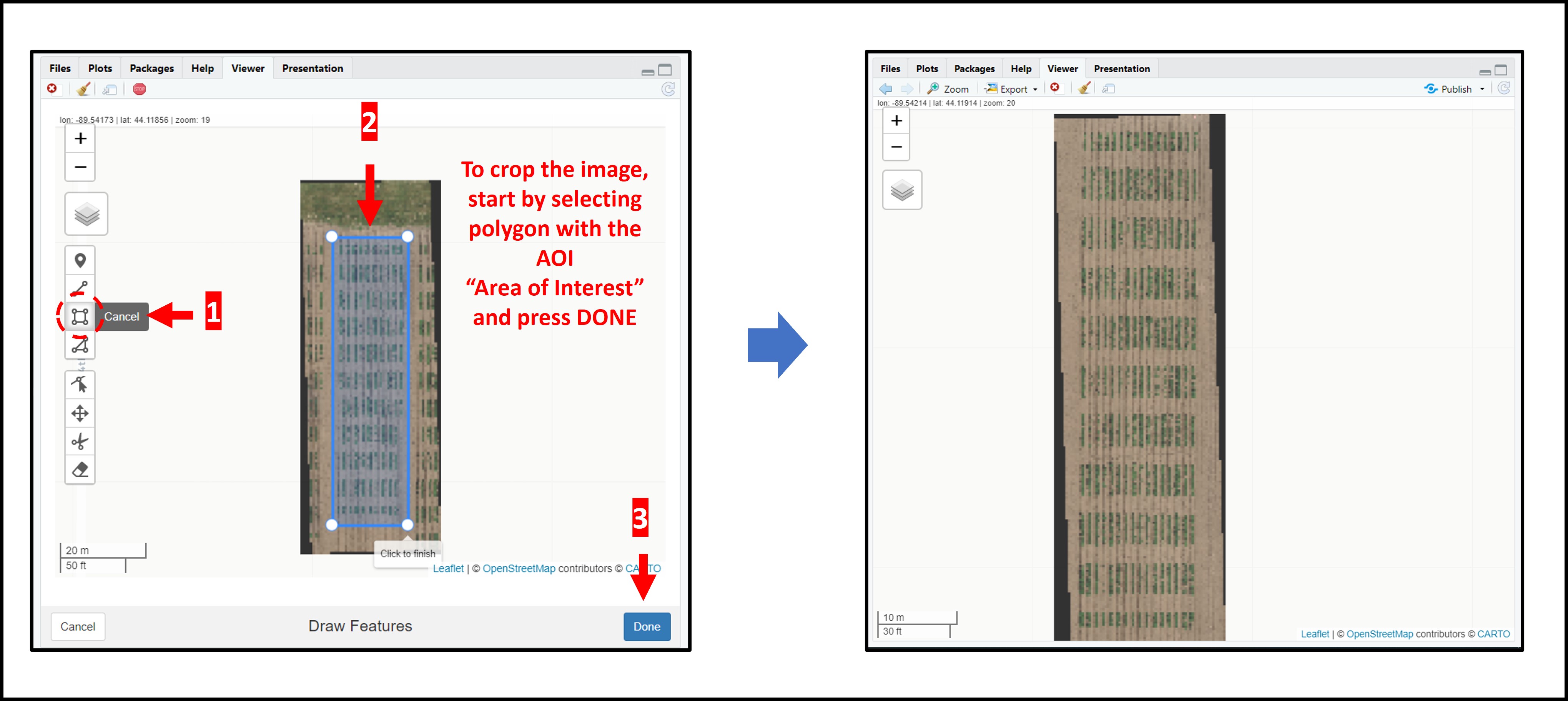
If necessary you can crop the mosaic/image to reduce size by selecting the aoi (area of interest) using fieldView with editor=TRUE:
aoi<-fieldView(EX1,editor = TRUE) EX1<-crop(EX1,aoi) # For heavy images (large, high resolution, etc.) please use: fast.plot=T fieldView(EX1)
```
3. Removing soil using vegetation indices
The presence of soil can introduce bias in the data extracted from the image. Therefore, removing soil from the image is one of the most important steps for image analysis in agricultural science. Function to use:
fieldMask
```r EX1.RemSoil <- fieldMask(mosaic = EX1, Red = 1, Green = 2, Blue = 3, index = "HUE")
```
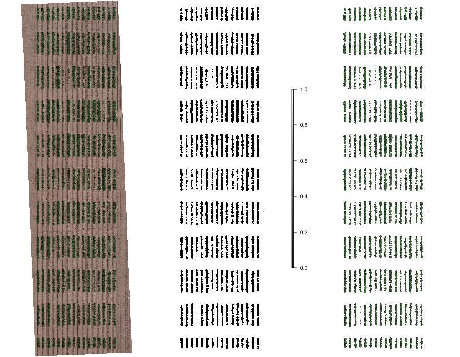
4. Building the plot shape file
Once the field has reached a correct straight position, the plot shape file can be drawn by selecting at least four points at the corners of the experiment. The number of columns and rows must be informed. At this point the experimental borders can be eliminated, in the example bellow the borders were removed in all the sides. Function to use is from FIELDimageR.Extra:
fieldShape_render
r
EX1.Shape<-fieldShape_render(mosaic = EX1,ncols = 14, nrows = 9)
fieldView(mosaic = EX1,
          fieldShape = EX1.Shape,
          type = 2,
          alpha = 0.2)
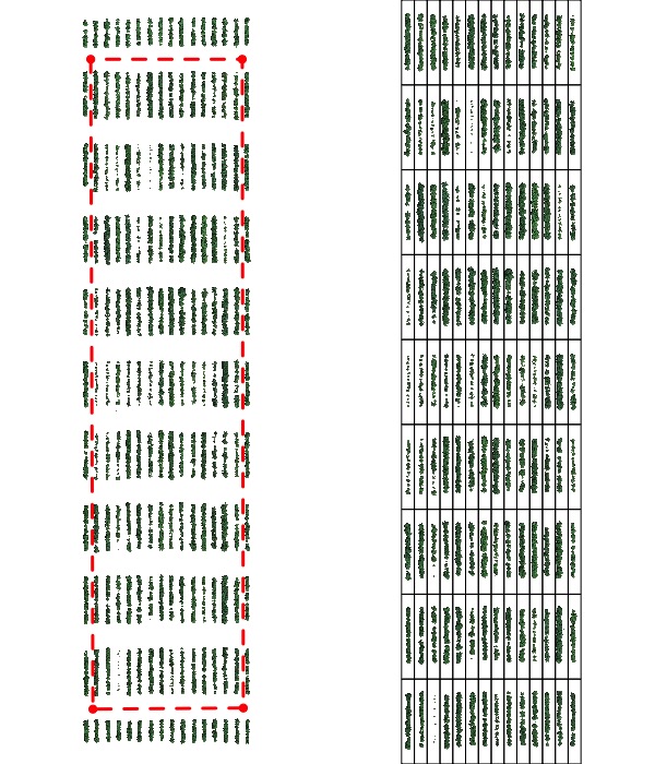
Attention: The plots are identified in ascending order from left to right and bottom to top (this is another difference from the
FIELDimageR::fieldShape) being evenly spaced and distributed inside the selected area independent of alleys.
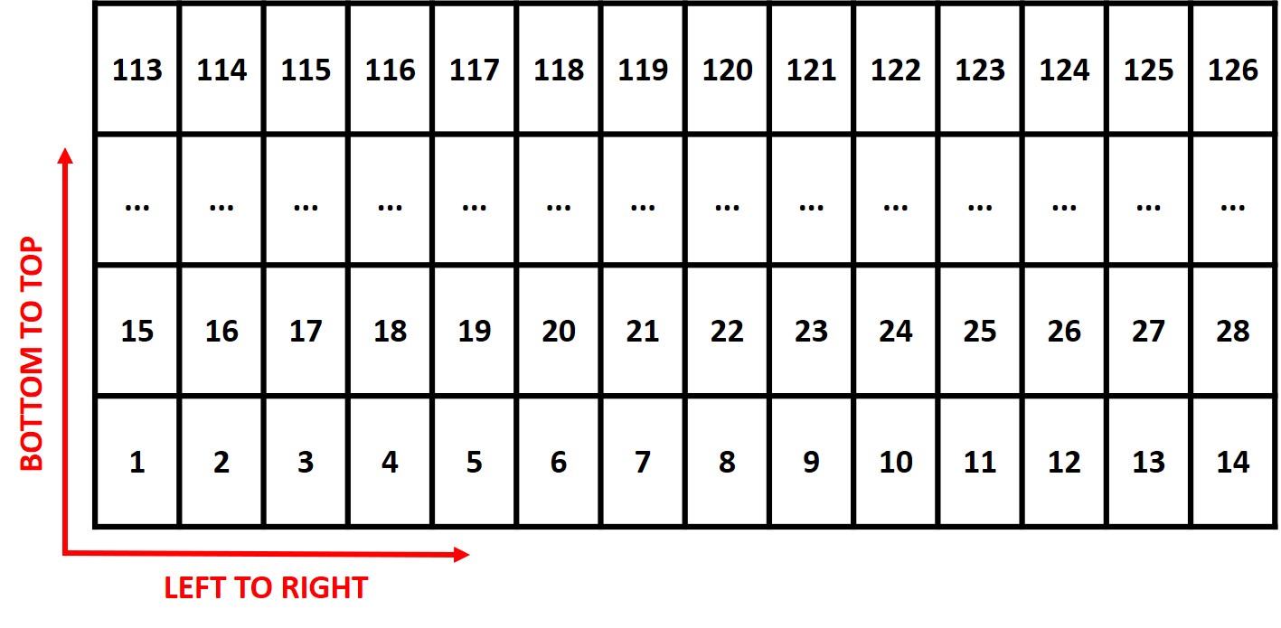
One matrix can be used to identify the plots position according to the image above. The function
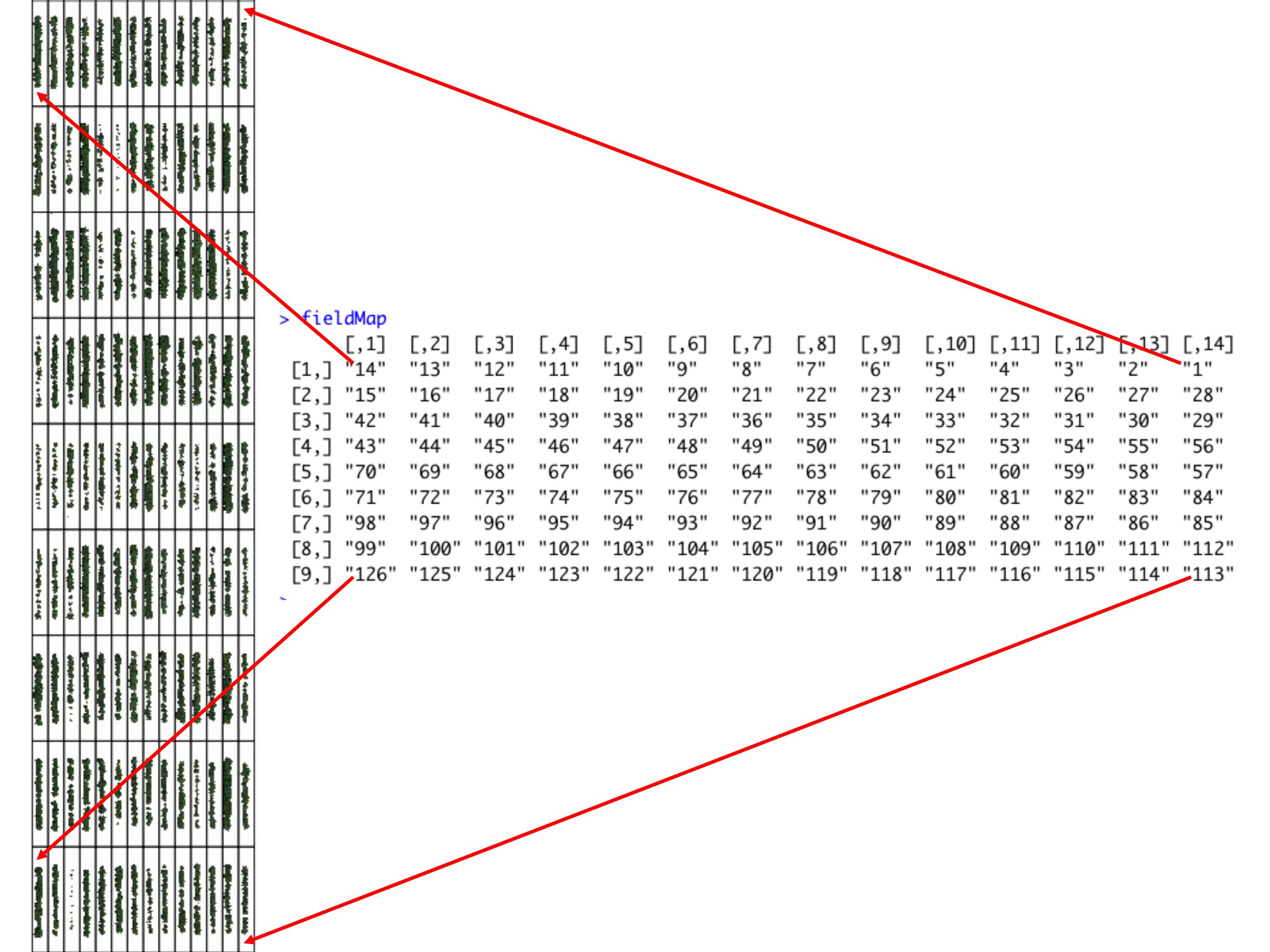
fieldMapcan be used to specify the plot ID automatic or any other matrix (manually built) also can be used. For instance, the new column PlotName will be the new identification. You can download an external table example here: DataTable.csv.
```r
Field map identification (name for each Plot). 'fieldPlot' argument can be a number or name.
DataTable<-read.csv("DataTable.csv",header = T)
fieldMap<-fieldMap(fieldPlot=DataTable$Plot, fieldColumn=DataTable$Row, fieldRow=DataTable$Range, decreasing=T)
fieldMap
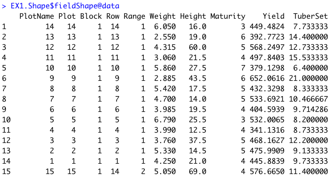
The new column PlotName is identifying the plots:
EX1.Shape<-fieldShape_render(mosaic = EX1, ncols = 14, nrows = 9, fieldMap = fieldMap, fieldData = DataTable, PlotID = "Plot") fieldView(mosaic = EX1, fieldShape = EX1.Shape, type = 2, alpha = 0.2)
```
```r
Joing all information in one "fieldShape_render" file:
EX1.Shape<-fieldShape_render(mosaic = EX1, ncols = 14, nrows = 9, fieldMap = fieldMap, fieldData = DataTable, PlotID = "Plot") fieldView(mosaic = EX1, fieldShape = EX1.Shape, type = 2, alpha = 0.2)
The new column PlotName is identifying the plots:
EX1.Shape
```
```r
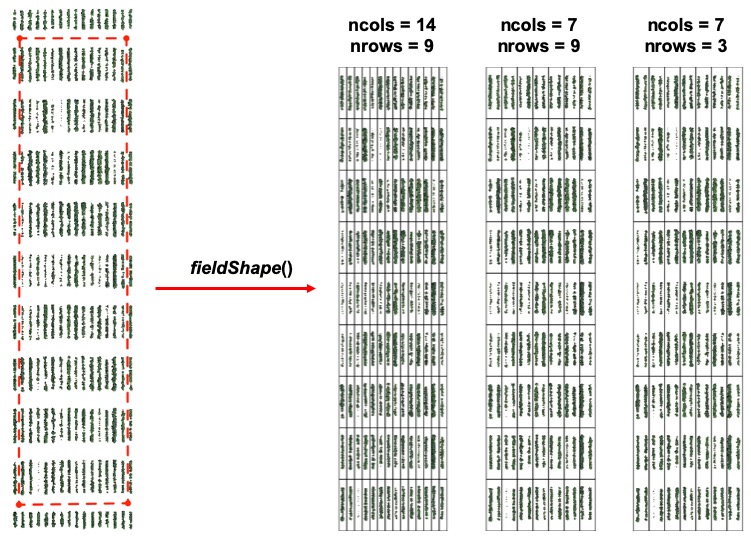
Different plot dimensions using "fieldShape":
ncols = 14 and nrows = 9
EX1.Shape.1Line<-fieldShape_render(mosaic = EX1, ncols = 14, nrows = 9)
ncols = 7 and nrows = 9
EX1.Shape.2lines<-fieldShape_render(mosaic = EX1, ncols = 7, nrows = 9)
ncols = 7 and nrows = 3
EX1.Shape.6lines<-fieldShape_render(mosaic = EX1, ncols = 7, nrows = 3)
```
5. Building vegetation indices
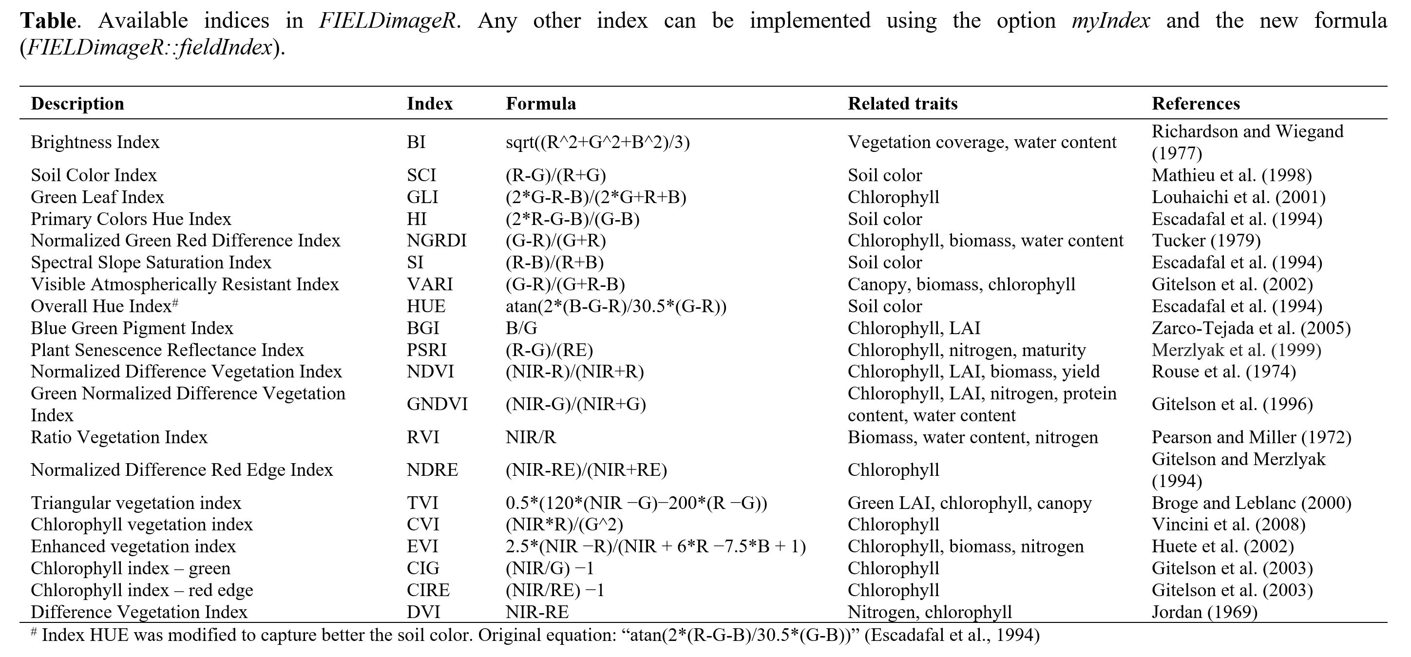
A general number of indices are implemented in FIELDimageR using the function
fieldIndex. Also, you can build your own index using the parametermyIndex.
```r
Calculating myIndex = "(Red-Blue)/Green" (not avaliable at 'FIELDimageR')
EX1.Indices<- fieldIndex(mosaic = EX1.RemSoil$newMosaic, Red = 1, Green = 2, Blue = 3, index = c("NGRDI","BGI"), myIndex = c("(Red-Blue)/Green"))
More than one myIndex code: myIndex = c("myIndex1","myIndex2","myIndex3")
EX1.Indices.myIndex<- fieldIndex(mosaic = EX1.RemSoil$newMosaic, Red = 1, Green = 2, Blue = 3, index = c("NGRDI","BGI"), myIndex = c("(Red-Blue)/Green","Red/Green","Blue/Green"))
```

Sugestion: This function could also be used to build an index to remove soil or weeds. First it is necessary to identify the threshold to differentiate soil from the plant material. At the example below (B), all values above 0.7 were considered as soil and further removed using
fieldMask(C & D).
```r EX1.Indices.BGI<- fieldIndex(mosaic = EX1, index = c("BGI"))
dev.off() hist(EX1.Indices.BGI$BGI) # Image segmentation start from 0.7 (soil and plants)
EX1.BGI<- fieldMask(mosaic = EX1, Red = 1, Green = 2, Blue = 3, index = "BGI", cropValue = 0.7, cropAbove = T)
Check if: cropValue=0.8 or cropValue=0.6 works better.
```

6. Counting the number of objects (e.g. plants, seeds, etc)
FIELDimageR can be used to evaluate stand count during early stages. A good weed control practice should be performed to avoid misidentification inside the plot. The mask output from
fieldMaskand the fieldshape output fromfieldShapemust be used. Function to use:fieldCount.
```r EX1.SC<-fieldCount(mosaic = EX1.RemSoil$mask, fieldShape = EX1.Shape, plot=T, col="blue")
```
```r
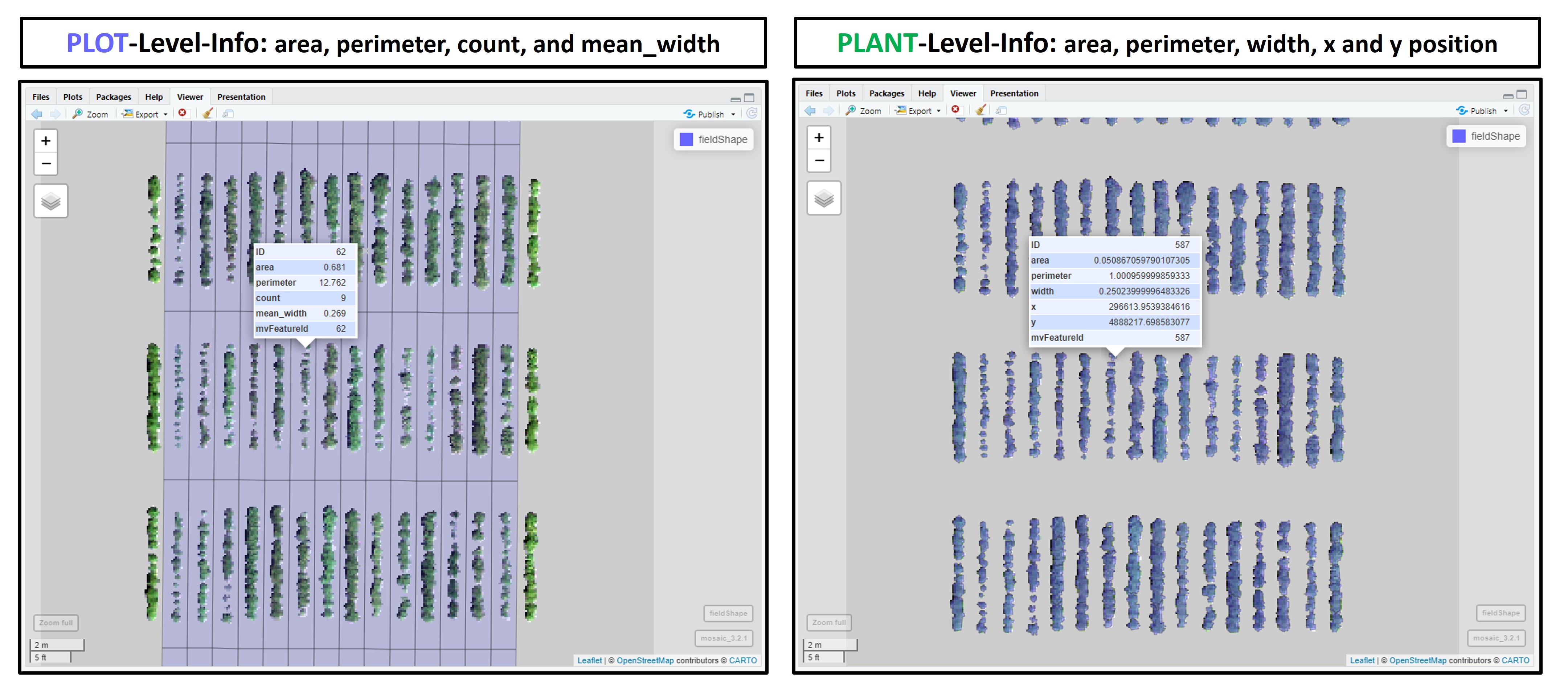
New shapeFile with objects in the plot. Data per plot in the grid: area, perimeter, count, and mean_width.
EX1.SC$plotlevel fieldView(mosaic = EX1.RemSoil$newMosaic, fieldShape = EX1.SC$plotlevel, type = 2, alpha = 0.2)
New shapeFile of single objects. Data per object (plant, pollen, etc.): area, perimeter, width, x and y position.
EX1.SC$objectlevel
fieldView(mosaic = EX1.RemSoil$newMosaic,
fieldShape = EX1.SC$objectlevel,
type = 2,
alpha = 0.5)
```
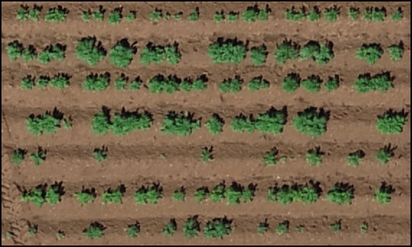
To refine stand count, we can further eliminate weeds (small plants) or outlying branches from the output using the parameter min Size. The following example uses an image available to download here:EX_StandCount.tif
```r
Uploading file
EX.SC<-rast("EX_StandCount.tif") plotRGB(EX.SC, r = 1, g = 2, b = 3)
Removing the soil
EX.SC.RemSoil<- fieldMask(mosaic = EX.SC, Red = 1, Green = 2, Blue = 3, index = "HUE")
Building the plot shapefile (ncols = 7 and nrows = 1)
EX.SC.Shape<-fieldShape_render(mosaic = EX.SC,
ncols = 7,
nrows = 1)
fieldView(mosaic = EX.SC,
fieldShape = EX.SC.Shape,
type = 2,
alpha = 0.2)
```
```r
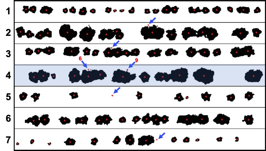
When all shapes are counted: minSize = 0.00
EX1.SC<-fieldCount(mosaic = EX.SC.RemSoil$mask, fieldShape = EX.SC.Shape, watershed = 0.05, plot = T)
EX1.SC$object_level # Identifies plants and small artifacts
fieldView(mosaic = EX.SC,
fieldShape = EX1.SC$object_level,
type = 2,
alpha = 0.2)
```
```r
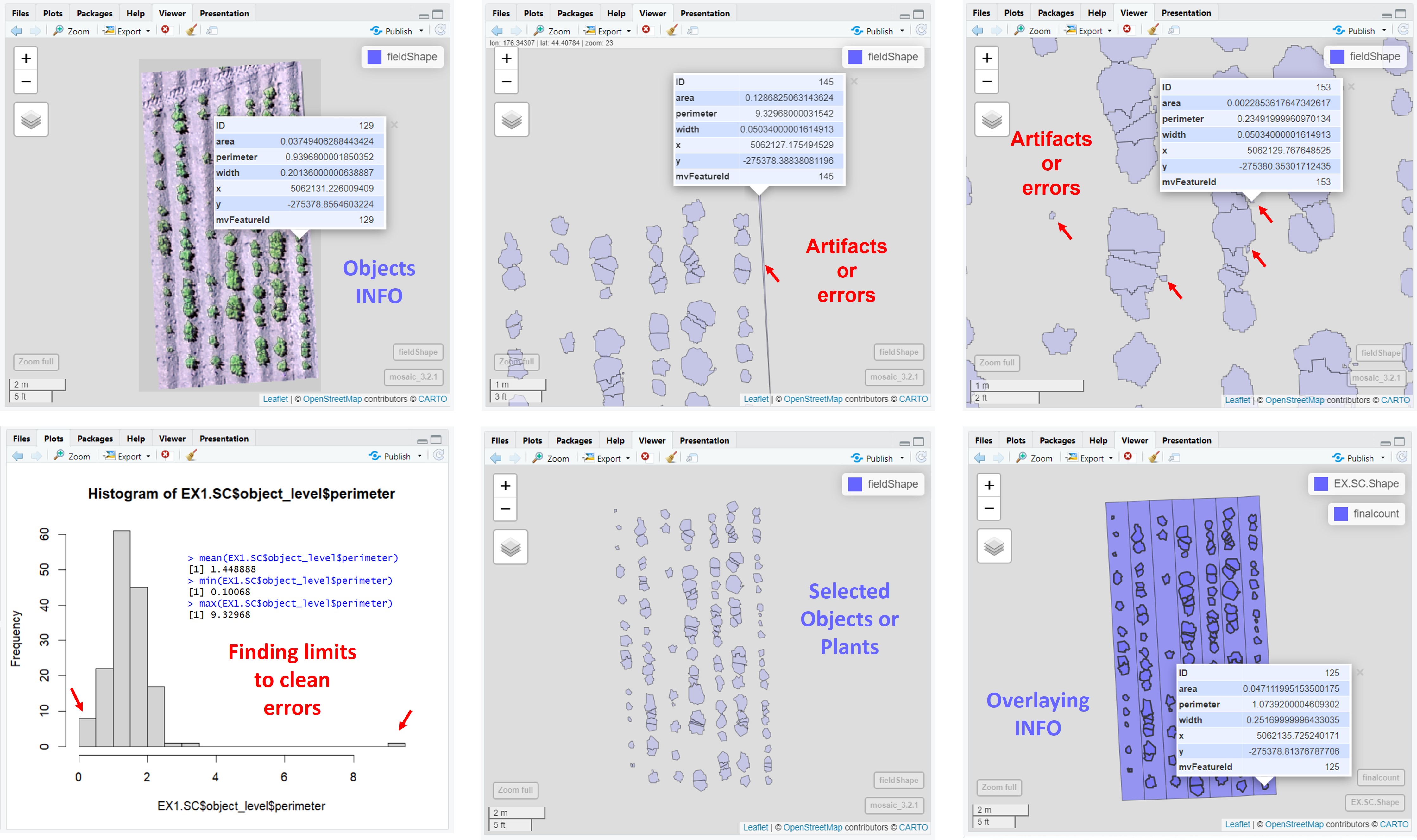
When all shapes with perimeter greater than 0.4 and lower than 4 are selected:
hist(EX1.SC$objectlevel$perimeter,breaks=30) # Errors= 0.4 < perimeter > 4 max(EX1.SC$objectlevel$perimeter) min(EX1.SC$objectlevel$perimeter) mean(EX1.SC$objectlevel$perimeter)
finalcount<-EX1.SC$object_level %>% dplyr::filter(perimeter>0.4 & perimeter<4) # Errors= 0.4 < perimeter > 4
mapview(list(EX.SC.Shape,finalcount))
fieldView(mosaic = EX.SC,
fieldShape = finalcount,
type = 2,
alpha = 0.2)
```
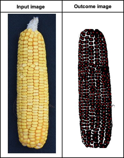
fieldCountalso can be used to count other objects (e.g. seed, pollen, etc). The example below FIELDimageR pipeline was used to count seeds in a corn ear.
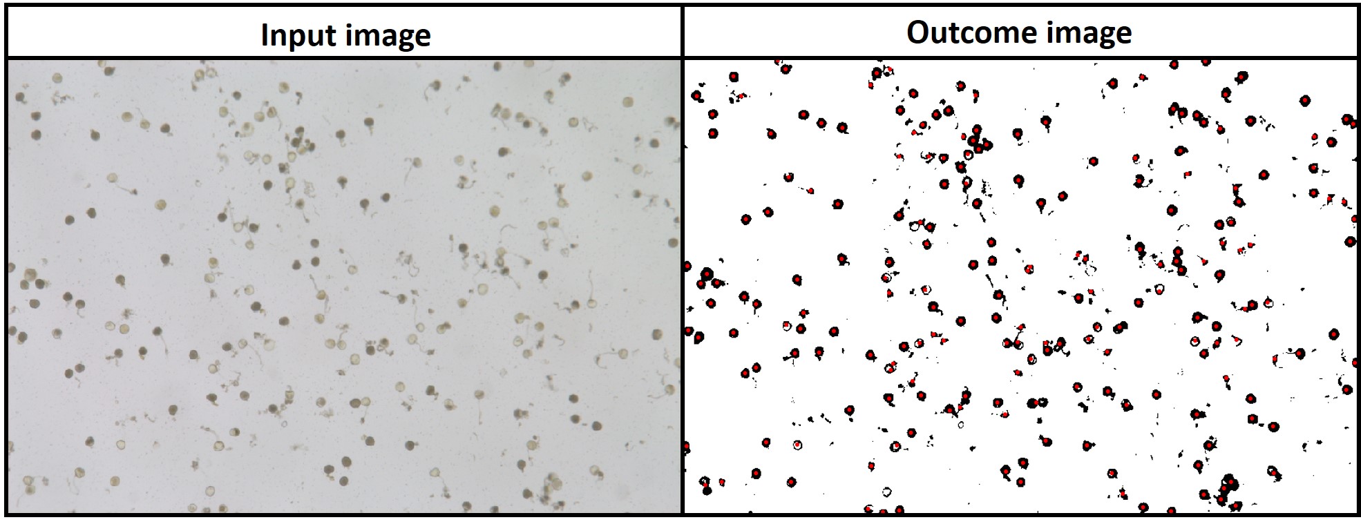
fieldMaskwith index BIM (Brightness Index Modified) was used to identify pollen andfieldCountwas used to count total and germinated pollens per sample. Download EX_Pollen.jpeg
```r
Uploading image
EX.P<-rast("EX_Pollen.jpeg")
Reducing image resolution (fast analysis)
EX.P<-aggregate(EX.P,fact=4) plotRGB(EX.P, r = 1, g = 2, b = 3)
Using index "BIM" to remove background (above 19)
EX.P<-imgLAB(EX.P) EX.P.R1<- fieldMask(mosaic = EX.P,index = "BIM", cropValue = 19, cropAbove = T) fieldView(EX.P.R1$newMosaic)
Counting all pollens area>1000 (all sample)
EX.P.Total<-fieldCount(mosaic = EX.P.R1$mask, plot=T)
library(leafsync) m1<-fieldView(EX.P) m2<-mapview(EX.P.Total) sync(m1,m2)
hist(EX.P.Total$area,breaks=50) pollencount<-EX.P.Total %>% dplyr::filter(area>1000) m2<-mapview(pollencount) sync(m1,m2)
Using index "BIM" to identify germinated pollen grain (removing values above 16)
EX.P.R2<- fieldMask(mosaic = EX.P, index = "BIM", cropValue = 16, cropAbove = T) m2<-fieldView(EX.P.R2$newMosaic) sync(m1,m2)
Counting all germinated pollen
EX.P.Ger<-fieldCount(mosaic = EX.P.R2$mask, plot=T) m2<-mapview(EX.P.Ger) sync(m1,m2)
```
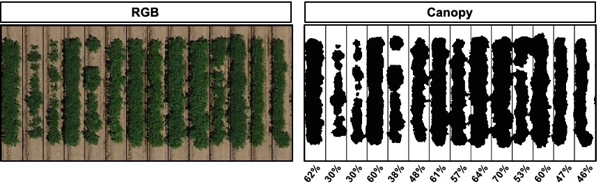
7. Evaluating the object area percentage (e.g. canopy)
FIELDimageR can also be used to evaluate the canopy percentage per plot. The mask output from
fieldMaskand the fieldshape output fromfieldShapemust be used. Function to use:fieldArea. The parameter n.core is used to accelerate the canopy extraction (parallel).
```r EX1.Canopy<-fieldArea(mosaic = EX1.RemSoil$newMosaic, fieldShape = EX1.Shape) EX1.Canopy
```
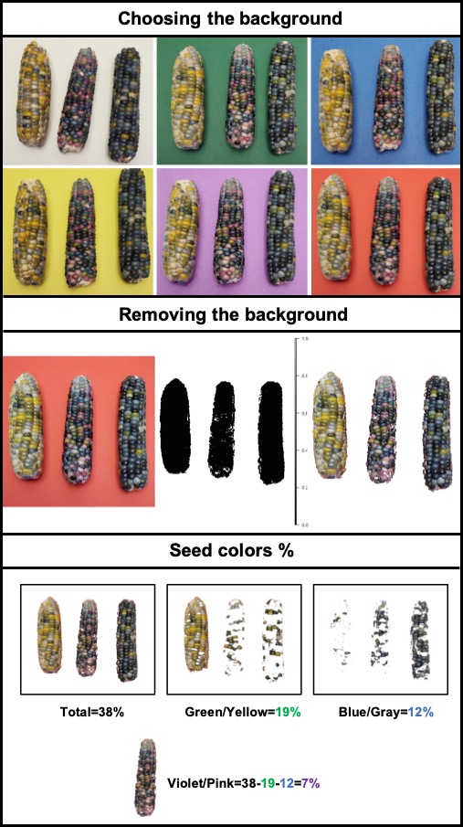
fieldAreaalso can be associated with the functionfieldMaskto evaluate the proportion of seed colors in Glass Gems Maize. An important step is to choose the right contrasting background to differentiate samples. The same approach can be used to evaluate the percentage of disease/pests’ damage, land degradation, deforestation, etc.
8. Extracting data from field images
The function extract from terra is adapted for agricultural field experiments through function
FIELDimageR.Extra::fieldInfo_extra.
```r EX1.Info<- fieldInfo_extra(mosaic = EX1.Indices,fieldShape = EX1.Shape) EX1.Info
```
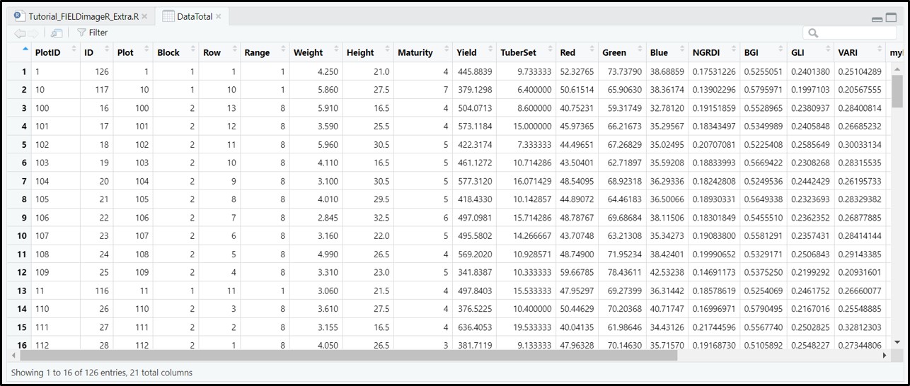
9. Estimating plant height and biomass
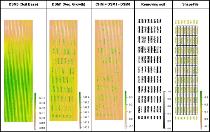
The plant height can be estimated by calculating the Canopy Height Model (CHM) and biomass by calculating Canopy Volume Model (CVM). This model uses the difference between the Digital Surface Model (DSM) from the soil base (before there is any sproute, Download EX_DSM0.tif) and the DSM file from the vegetative growth (once plants are grown, Download EX_DSM1.tif). To calculate CHM and CVM we used the function
fieldHeight, where CVM=cellSize(CHM)CHM. The next step is removing the soil effect with *fieldMask** and then usefieldInfo_extrato extract information as mean, max, min, sum, and quantile.
```r
Uploading files from soil base (EXDSM0.tif) and vegetative growth (EXDSM1.tif):
DSM0 <- rast("EXDSM0.tif") DSM1 <- rast("EXDSM1.tif")
Canopy Height Model (CHM) and Canopy Volume Model (CVM):
CHVM<-fieldHeight(DSM0,DSM1) plot(CHVM)
Removing the soil using mask from step 4:
CHVM <- fieldMask(CHVM, mask = EX1.RemSoil$mask)
Extracting the estimate plant height average (PlantHeight):
EX1.Shape<- fieldInfo_extra(mosaic = CHVM$newMosaic$height, fieldShape = EX1.Shape, fun=mean) colnames(EX1.Shape)[dim(EX1.Shape)[2]-1]<-"PlantHeight" # Changing trait name!
Extracting the estimate plant height at 10% and 90% of quantile:
probs = c(0.1,0.9) EPH.Extract<-extract(x = CHVM$newMosaic$height, y = EX1.Shape,quantile, probs = probs, na.rm=TRUE) EX1.Shape<-merge(EX1.Shape,EPH.Extract,by="ID") colnames(EX1.Shape)[c(dim(EX1.Shape)[2]-2, dim(EX1.Shape)[2]-1)]<-c("PH.10","PH.90") # Changing trait name!
Extracting plant volume or digital biomass (PlantBiomass):
EX1.Shape<- fieldInfo_extra(mosaic = CHVM$newMosaic$volume, fieldShape = EX1.Shape, fun=sum) colnames(EX1.Shape)[dim(EX1.Shape)[2]-1]<-"PlantBiomass" # Changing trait name!
Data Visualization:
m1<-fieldView(EX1) m2<-fieldView(mosaic = CHVM$newMosaic$height, fieldShape = EX1.Shape, type = 2, alpha = 0.5)
library(leafsync) sync(m1,m2)
```
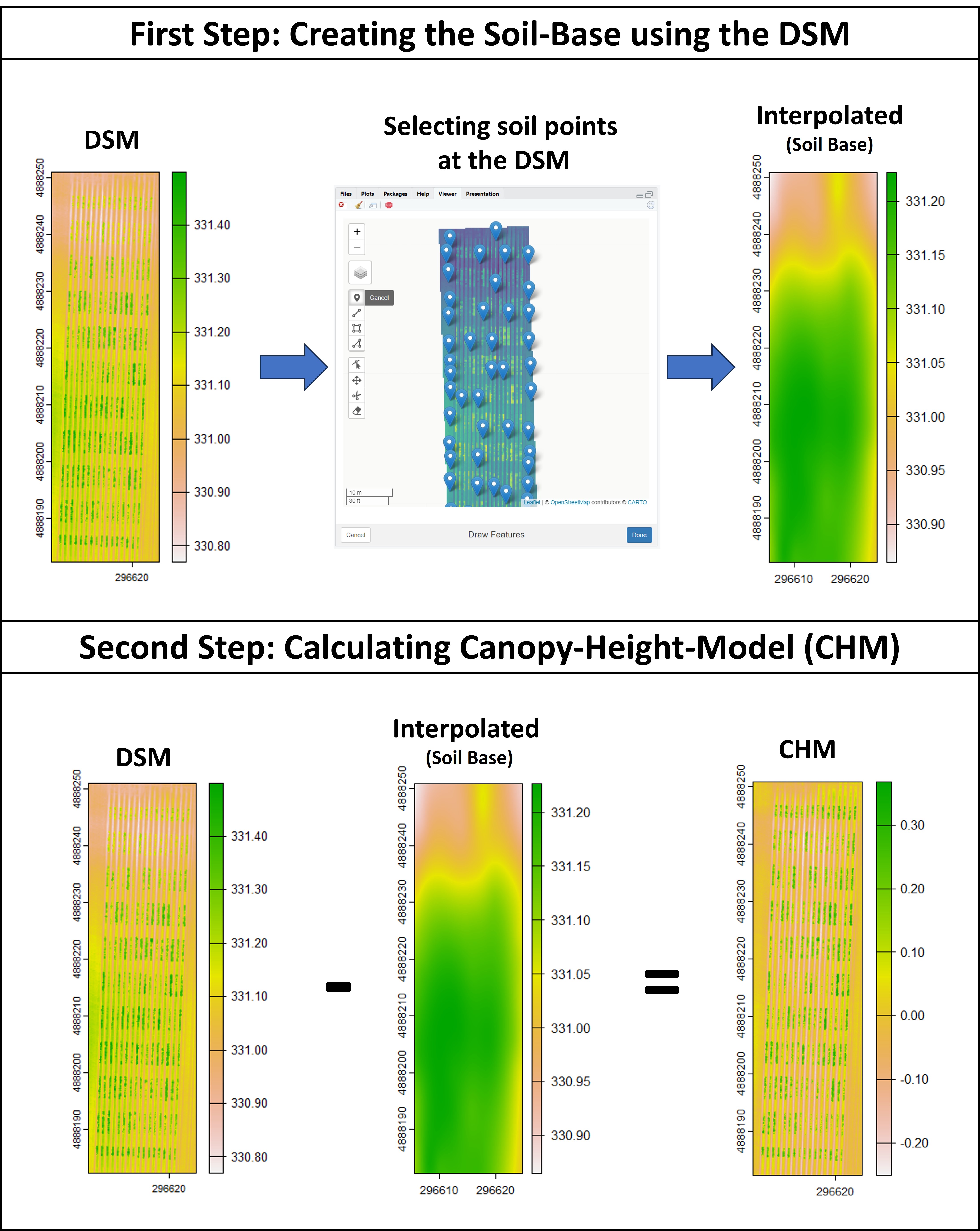
Creating interpolated mosaics based on sampled points
Attention: In case the user has only one flight (e.g., one DSM) the function
fieldInterpolatecan be used to creat the soil-reference based on sampled points at the DSM1.
```r
Creating the soil reference based on the DSM1:
DSM1 <- rast("EX_DSM1.tif")
Selecting points from soil:
points<-fieldView(DSM1,editor = T)
Creating the interpolated soil-base (DSM0.New):
DSM0.New<-fieldInterpolate(DSM1,points) plot(DSM0.New)
New Canopy-Height-Model (CHM):
CHM<-DSM1-DSM0.New plot(CHM)
```
10. Distance between plants, objects length, and removing objects (plot, cloud, weed, etc.)
The function
fieldObjectcan be used to take relative measurement from objects (e.g., area, "x" distance, "y" distance, number, extent, etc.) in the entire mosaic or per plot using the fieldShape file. Download example here: EX_Obj.jpg.
```r
Uploading file (EX_Obj.tif)
EX.Obj <- rast("EX_Obj.jpg") plotRGB(EX.Obj) EX.Obj <- aggregate(EX.Obj,4)
Removing the background
EX.Obj<-imgLAB(EX.Obj) EX.Obj.M<- fieldMask(mosaic = EX.Obj, index = "BGI",cropValue = 0.7,cropAbove = T)
Taking measurements:
EX.Obj.D<-fieldCount(mosaic = EX.Obj.M$mask, plot = T)
fieldView(EX.Obj,EX.Obj.D) plotRGB(EX.Obj) plot(EX.Obj.D$geometry, add=T, border="red") plot(EX.Obj.D[1,], add=T, col="yellow") EX.Obj.I<- fieldIndex(mosaic = EX.Obj,index = c("SI","BGI","BI")) EX.Obj.Data<-fieldInfo_extra(mosaic = EX.Obj.I[[c("SI","BGI","BI")]], fieldShape = EX.Obj.D) plot(EX.Obj.Data)
Data visualization:
library(reshape2) Data.Obj1<-melt(EX.Obj.Data,measure.vars = c("area","perimeter","width","SI","BGI","BI"))
library(ggplot2) ggplot(Data.Obj1, aes(x=value, fill=variable)) + geomhistogram(aes(y=..density..), colour="black")+ geomdensity(alpha=.2)+ facet_wrap(~variable, scales = "free")
```

The function
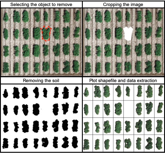
fieldCropcan be used to remove objects from the field image. For instance, the parameter remove=TRUE and nPoint should be used to select the object boundaries to be removed. Download EX_RemObj.tif).
```r
Uploading file (EX_RemObj.tif)
EX.RemObj <- rast("EX_RemObj.tif")
Selecting the object boundaries to be removed (nPoint = 10)
EX.RemObj.Crop <- fieldCrop(mosaic = EX.RemObj, remove = T, nPoint = 10) # Selecting the plant in plot 13
Removing the soil
EX.RemObj.RemSoil<- fieldMask(mosaic = EX.RemObj.Crop,index = "HUE")
Building the plot shapefile (ncols = 8 and nrows = 4)
EX.RemObj.Shape<-fieldShape_render(mosaic = EX.RemObj.RemSoil,ncols = 8, nrows = 4)
Building indice (NGRDI)
EX.RemObj.Indices<- fieldIndex(mosaic = EX.RemObj.RemSoil$newMosaic,index = c("NGRDI"))
Extracting data (NGRDI)
EX.RemObj.Info<- fieldInfo_extra(mosaic = EX.RemObj.Indices$NGRDI, fieldShape = EX.RemObj.Shape)
Comparing plots values (the plant in plot 13 was removed and its value must be lower than plot 12 and 14)
EX.RemObj.Info[c(12,13,14),]
```
The function
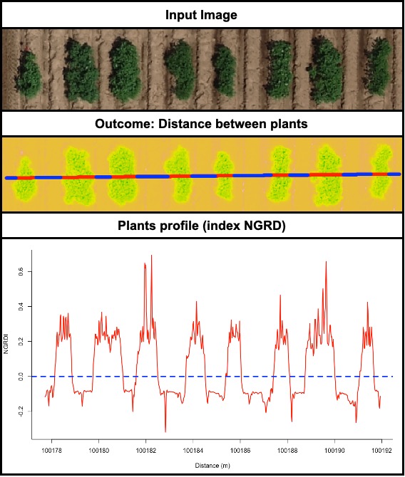
fieldDrawcan be used to draw lines or polygons in the field image. This function allows to extract information of specific positions in the field (x, y, value). Also, this function can be used to evaluate distances between objects (for example: distance between plants in a line) or either objects length (for example: seed length, threes diameter, etc.). Let's use the image above to evaluate the distance between potato plots and later to extract NGRDI values from a line with soil and vegetation to observe the profile in a distance plot.
```r
Uploading file (EX_RemObj.tif)
EX.Dist <- rast("EX_RemObj.tif")
vegetation indices
EX.Dist.Ind <- fieldIndex(mosaic = EX.Dist,index = c("NGRDI"))
Removing the soil
EX.Dist.RemSoil <- fieldMask(mosaic = EX.Dist.Ind)
Evaluating distance between plants. Remember to press ESC when finished to draw the line.
EX.Dist.Draw <- fieldDraw(mosaic = EX.Dist.RemSoil$mask, dist = T, value = 1, # Use the number to identify the object to be measured (1 for space and 0 for plants) distSel = 0.4) EX.Dist.Draw$drawDist # Distance between plants
Making plots
plot(EX.Dist.Ind$NGRDI) points(EX.Dist.Draw$drawData$x,EX.Dist.Draw$drawData$y, col="red",pch=16,cex=0.7) points(EX.Dist.Draw$drawSegments$x,EX.Dist.Draw$drawSegments$y, col="blue",pch=16,cex=0.7) lines(EX.Dist.Draw$drawDist[1,c("x1","x2")],EX.Dist.Draw$drawDist[1,c("y1","y2")], col="green",lwd=5)
Evaluating an specific layer profile (e.g. NGRDI)
EX.Dist.Draw.2 <- fieldDraw(mosaic = EX.Dist.Ind, ndraw = 4, # Making 4 lines (press ESC to conclude each line) lwd = 5) EX.Data<-EX.Dist.Draw.2$Draw1$drawData dev.off() plot(x = EX.Data$x, y = EX.Data$NGRDI, type="l", col="red",lwd=2,xlab="Distance (m)", ylab="NGRDI") abline(h=0.0,col="blue", lty=2, lwd=3)
Making polygons and extracting data per cell
EX.Dist.Draw.3 <- fieldDraw(mosaic = EX.Dist.Ind, line = F, # Making 2 polygons (press ESC to conclude each polygon) ndraw = 2, lwd = 5) plotRGB(EX.Dist.RemSoil$newMosaic) plot(EX.Dist.Draw.3$Draw1$drawObject, col="red",add=T)
```
11. Resolution and computing time
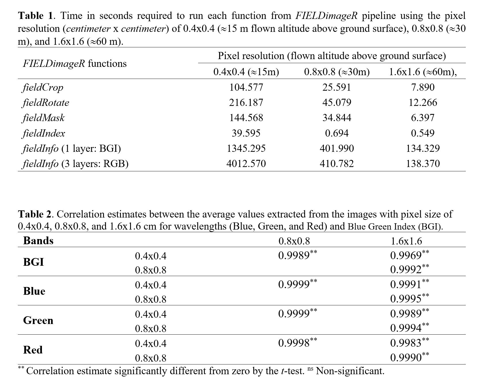
The influence of image resolution was evaluated at different steps of the FIELDimageR pipeline. For this propose, the resolution of image EX1RGBHighResolution.tif Download was reduced using the function raster::aggregate in order to simulate different flown altitudes Above Ground Surface (AGS). The parameter fact was used to modify the original image resolution (0.4x0.4 cm with 15m AGS) to: first, fact=2 to reduce the original image to 0.8x0.8 cm (simulating 30m AGS), and fact=4 to reduce the original image to 1.6x1.6 (simulating 60m AGS). The steps (i) removing soil, (ii) building vegetation index (BGI), and (iii) getting information were evaluated using the function system.time output elapsed (R base).
```r
Image and resolution decrease
RES1<-rast("EX1RGBHighResolution.tif") RES2<-aggregate(RES1, fact=2) RES4<-aggregate(RES_1, fact=4)
res(RES1) res(RES2) res(RES_4)
par(mfrow=c(1,3)) plotRGB(RES1) plotRGB(RES2) plotRGB(RES_4)
Removing Soil
system.time({RES1S <- fieldMask(RES1,index="HUE")}) system.time({RES2S <- fieldMask(RES2,index="HUE")}) system.time({RES4S <- fieldMask(RES_4,index="HUE")})
Indices
system.time({RES1I <- fieldIndex(RES1S$newMosaic,index=c("BGI"))}) system.time({RES2I <- fieldIndex(RES2S$newMosaic,index=c("BGI"))}) system.time({RES4I <- fieldIndex(RES4S$newMosaic,index=c("BGI"))})
Get Information (1 Band)
system.time({RES1Info <- fieldInfoextra(RES1I$BGI,fieldShape = EX1.Shape)}) system.time({RES2Info <- fieldInfoextra(RES2I$BGI,fieldShape = EX1.Shape)}) system.time({RES4Info <- fieldInfoextra(RES4_I$BGI,fieldShape = EX1.Shape)})
Get Information (3 Bands)
system.time({RES1Info2 <- fieldInfoextra(RES1I[[c(1,2,3)]],fieldShape = EX1.Shape)}) system.time({RES2Info2 <- fieldInfoextra(RES2I[[c(1,2,3)]],fieldShape = EX1.Shape)}) system.time({RES4Info2 <- fieldInfoextra(RES4_I[[c(1,2,3)]],fieldShape = EX1.Shape)})
Correlation
DataBGI <- data.frame(R1=RES1Info$BGI, R2=RES2Info$BGI, R4=RES4Info$BGI) DataBlue <- data.frame(R1=RES1Info2$Blue, R2=RES2Info2$Blue, R4=RES4Info2$Blue) DataGreen <- data.frame(R1=RES1Info2$Green, R2=RES2Info2$Green, R4=RES4Info2$Green) DataRed <- data.frame(R1=RES1Info2$Red, R2=RES2Info2$Red, R4=RES4Info2$Red) cor(DataBGI) cor(DataBlue) cor(DataGreen) cor(DataRed)
```
The time to run one function using the image with pixel size of 0.4x0.4 cm can be 10 (
fieldInfo) to 70 times (fieldIndex) slower than the image with pixel size of 1.6x1.6 cm (Table 1). The computing time to extract BGI index (one layer) with 0.4x0.4 cm was ~23 min whereas only ~7 min with the 0.8x0.8 cm image, and ~2 min using the 1.6x1.6 cm image. the time to extract the RGB information (three layers) was ~2.3 min for the 1.6x1.6 cm image and ~66 min for the 0.4x0.4 cm image. It is important to highlight that the resolution did not affect the plots mean, it has a correlation >99% between 0.4x0.4 cm and 1.6x1.6 (Table 2). High resolution images showed to require higher computational performance, memory, and storage space. We experienced that during the image collection in the field a low altitudes flight needs more batteries and a much greater number of pictures, and consequently longer preprocessing images steps to build ortho-mosaics.
12. Crop growth cycle
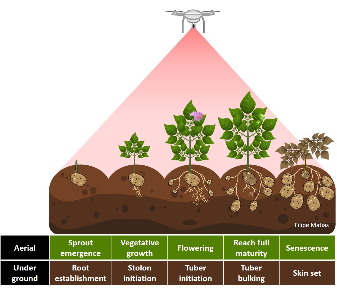
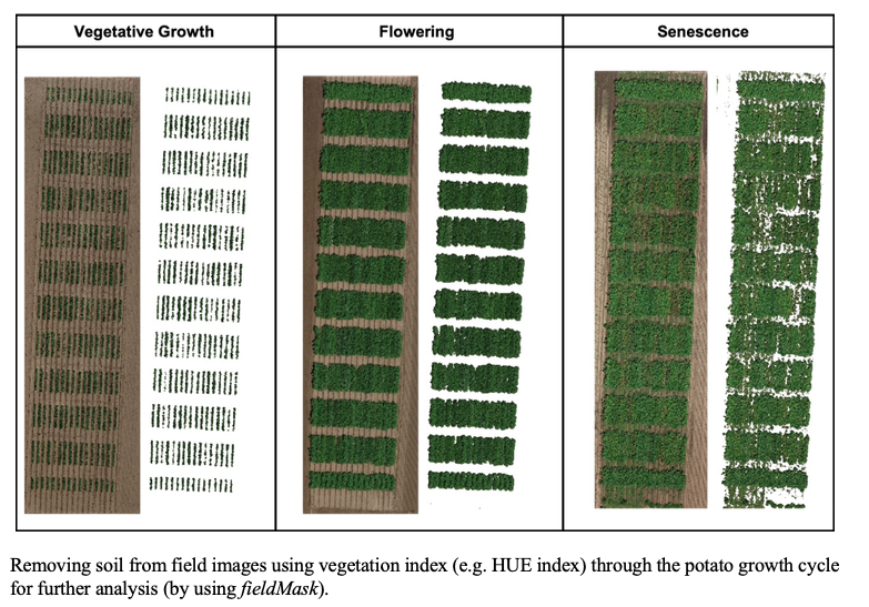
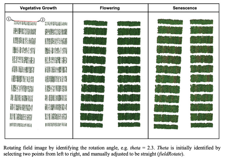
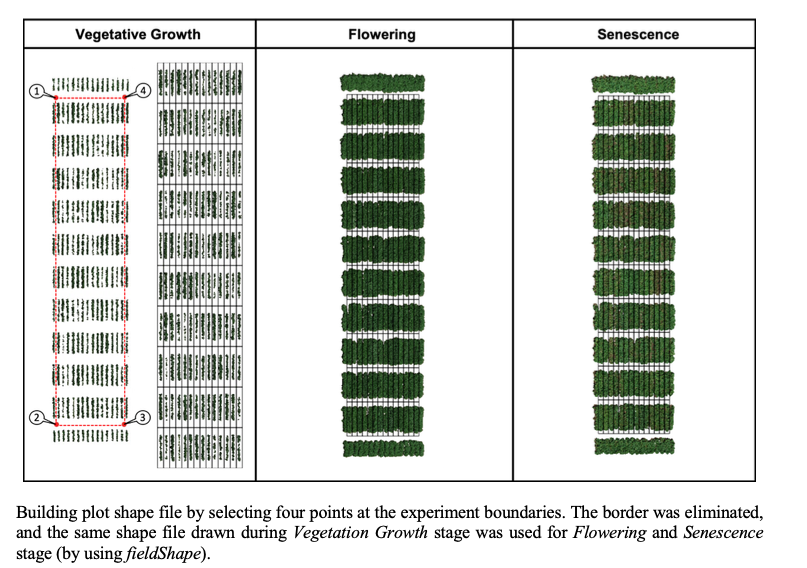
The same rotation theta from step 3, mask from step 4, and plot shape file from step 5, can be used to evaluate mosaics from other stages in the crop growth cycle. Here you can download specific images from flowering and senecense stages in potatoes. (Flowering: EX2_RGB.tif and Senescence: EX3_RGB.tif)
```r
Uploading Flowering (EX2RGB.tif) and Senescence (EX3RGB.tif) files:
EX2 <- rast("EX2RGB.tif") EX3 <- rast("EX3RGB.tif")
Cropping the image using the previous shape from step 2:
EX2.Crop <- fieldCrop(mosaic = EX2,fieldShape = EX1.Crop, plot = T) EX3.Crop <- fieldCrop(mosaic = EX3,fieldShape = EX1.Crop, plot = T)
Rotating the image using the same theta from step 3:
EX2.Rotated<-fieldRotate(EX2.Crop,theta = 2.3, plot = T) EX3.Rotated<-fieldRotate(EX3.Crop,theta = 2.3, plot = T)
Removing the soil using index and mask from step 4:
EX2.RemSoil<-fieldMask(EX2.Rotated,index="HUE",cropValue=0,cropAbove=T,plot=T) EX3.RS<-fieldMask(EX3.Rotated,index="HUE",cropValue=0,cropAbove=T,plot=T) # Removing soil at senescence stage EX3.RemSoil<-fieldMask(EX3.RS$newMosaic,mask = EX2.RemSoil$mask ,cropValue=0,cropAbove=T,plot=T) # Removing weeds from senescence stage with flowering mask
Building indices
EX2.Indices <- fieldIndex(EX2.RemSoil$newMosaic,Red=1,Green=2,Blue=3, index = c("NGRDI","BGI"), myIndex = c("(Red-Blue)/Green")) EX3.Indices <- fieldIndex(EX3.RemSoil$newMosaic,Red=1,Green=2,Blue=3, index = c("NGRDI","BGI"), myIndex = c("(Red-Blue)/Green"))
Extracting data using the same fieldShape file from step 5:
EX2.Info<- fieldInfoextra(mosaic = EX2.Indices$myIndex,fieldShape = EX1.Shape) EX3.Info<- fieldInfoextra(mosaic = EX3.Indices$myIndex,fieldShape = EX1.Shape)
Data.Cycle<-data.frame(EX1=EX1.Info$myIndex, EX2=EX2.Info$myIndex, EX3=EX3.Info$myIndex)
Data.Cycle
```

13. Multispectral and Hyperspectral images
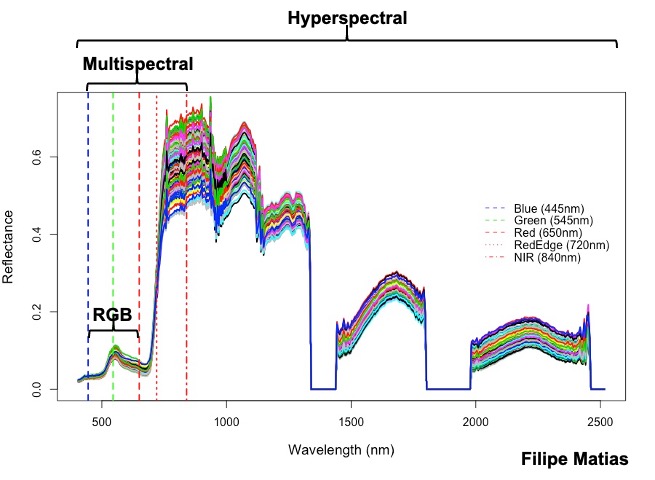
FIELDimageRcan be used to analyze multispectral and hyperspectral images. The same rotation theta, mask, and plot shape file used to analyze RGB mosaic above can be used to analyze multispectral or hyperspectral mosaic from the same field.
Multispectral: You can dowload a multispectral example here: EX1_5Band.tif
```r
Multispectral
Uploading multispectral mosaic:
EX1.5b <- rast("EX1_5Band.tif")
Cropping the image using the previous shape from step 2:
EX1.5b.Crop <- fieldCrop(mosaic = EX1.5b,fieldShape = EX1.Crop, plot = T)
Rotating the image using the same theta from step 3:
EX1.5b.Rotated<-fieldRotate(EX1.5b.Crop,theta = 2.3, plot = T)
Removing the soil using index and mask from step 4:
EX1.5b.RemSoil<-fieldMask(EX1.5b.Rotated,Red=1,Green=2,Blue=3,index="HUE",cropValue=0,cropAbove=T,plot=T)
Building indices (NDVI and NDRE)
EX1.5b.Indices <- fieldIndex(EX1.5b.RemSoil$newMosaic,Red=1,Green=2,Blue=3,RedEdge=4,NIR=5, index = c("NDVI","NDRE"))
Extracting data using the same fieldShape file from step 5:
EX1.5b.Info<- fieldInfo_extra(mosaic = EX1.5b.Indices$NDVI,fieldShape = EX1.Shape)
```
Hyperspectral: in the following example you should download the hyperspectral tif file (EX_HYP.tif), the 474 wavelength names (namesHYP.csv), and the field map data (DataHYP.csv).
```r
Hyperspectral
Uploading hyperspectral file with 474 bands (EX_HYP.tif)
EX.HYP<-rast("EX_HYP.tif")
Wavelengths (namesHYP.csv)
NamesHYP<-as.character(read.csv("namesHYP.csv")$NameHYP)
Building RGB image
R<-EX.HYP[[78]] # 651nm (Red) G<-EX.HYP[[46]] # 549nm (Green) B<-EX.HYP[[15]] # 450nm (Blue) RGB<-rast(c(R,G,B)) plotRGB(RGB, stretch="lin")
Removing soil using RGB (index NGRDI)
RGB.S<-fieldMask(RGB,index="NGRDI",cropValue = 0.0, cropAbove = F)
Data frame with field information to make the Map
Data<-read.csv("DataHYP.csv") Map<-fieldMap(fieldPlot = as.character(Data$Plot),fieldRow = as.character(Data$Range),fieldColumn = as.character(Data$Row),decreasing = T)
Building plot shapefile using RGB as base
plotFile<-fieldShape_render(RGB.S,ncols = 14, nrows = 14, fieldMap = Map,fieldData = Data, PlotID = "Plot")
Removing soil using the RGB mask
EX.HYP.S<-fieldMask(EX.HYP,mask = RGB.S$mask, plot = F)
Extracting data (474 bands)
EX.HYP.I<-fieldInfo_extra(EX.HYP.S$newMosaic,fieldShape = plotFile)
Saving the new csv with hyperspectral information per plot
DataHYP<-EX.HYP.I[,-dim(EX.HYP.I)[2]] colnames(DataHYP)<-c(colnames(DataHYP)[1:9],NamesHYP) write.csv(DataHYP,"DataHypNew.csv",col.names = T,row.names = F)
Graphic
dev.off() DataHYP1<-EX.HYP.I$plotValue[,-1]
plot(x=as.numeric(NamesHYP),y=as.numeric(DataHYP1[1,]),type = "l",xlab = "Wavelength (nm)",ylab = "Reflectance", col="black",lwd=2,cex.lab=1.2) for(i in 2:dim(DataHYP1)[2]){ lines(x=as.numeric(NamesHYP),y=as.numeric(DataHYP1[i,]),type = "l",col=i,lwd=2) } abline(v=445,col="blue",lwd=2,lty=2) abline(v=545,col="green",lwd=2,lty=2) abline(v=650,col="red",lwd=2,lty=2) abline(v=720,col="red",lwd=2,lty=3) abline(v=840,col="red",lwd=2,lty=4) legend(list(x = 2000,y = 0.5),c("Blue (445nm)","Green (545nm)","Red (650nm)","RedEdge (720nm)","NIR (840nm)"), col =c("blue","green","red","red","red"),lty=c(2,2,2,3,4),box.lty=0)
```
14. Building shapefile with polygons (field blocks, pest damage, soil differences, etc)
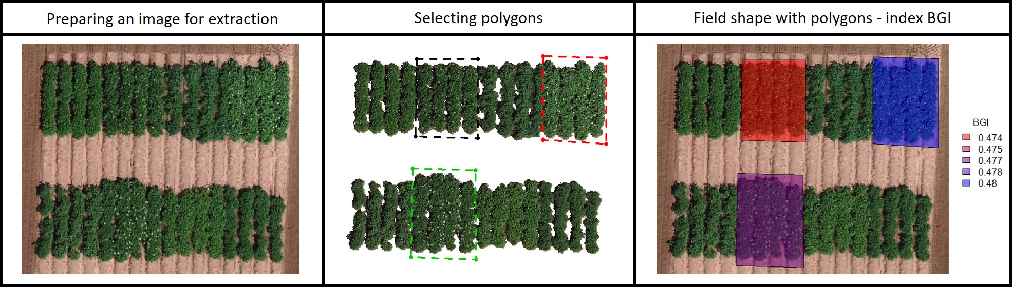
If your field area does not have a pattern to draw plots using the function fieldShape you can draw different polygons using the function fieldPolygon. To make the fieldshape file the number of polygons must be informed. For instance, for each polygon, you should select at least four points at the polygon boundaries area. This function is recommended to make shapefile to extract data from specific field blocks, pest damage area, soil differences, etc. If extent=TRUE the whole image area will be the shapefile (used to analyze multiple images for example to evaluate seeds, ears, leaves, diseases, etc.). Function to use: fieldPolygon. The following example uses an image available to download here: EX_polygonShape.tif.
```r
Uploading file (EX_polygonShape.tif)
EX.polygon<-rast("EX_polygonShape.tif") plotRGB(EX.polygon, r = 1, g = 2, b = 3)
Removing soil
EX.polygon.RemSoil<- fieldMask(mosaic = EX.polygon)
Data frame with polygons information
polygonData<-data.frame(ID=c("Polygon1","Polygon2","Polygon3"), FlowerColor=c("white","white","white"), FlowerPercent=c(20,40,50), LeafColor=c("dark","light","dark")) polygonData
Building plot shapefile with 3 polygons (select 4 points around the polygon area)
EX.polygon.Shape<-fieldPolygon(mosaic = EX.polygon.RemSoil, nPolygon = 3,nPoint = 4,ID = "ID", polygonData = polygonData,cropPolygon = T, polygonID = c("Polygon1","Polygon2","Polygon3")) plotRGB(EX.polygon.Shape$cropField)
Building indice (NGRDI and BGI)
EX.polygon.Indices<- fieldIndex(mosaic = EX.polygon.RemSoil$newMosaic, Red = 1, Green = 2, Blue = 3, index = c("NGRDI","BGI"))
Extracting data (NGRDI and BGI)
EX.polygon.Info<- fieldInfo_extra(mosaic = EX.polygon.Indices[[c("NGRDI","BGI")]], fieldShape = EX.polygon.Shape) EX.polygon.Info
Making graphics (BGI)
fieldPlot(fieldShape=EX.polygon.Info,
fieldAttribute="BGI",
mosaic=EX.polygon, color=c("red","blue"), alpha = 0.5)
```
15. Making plots
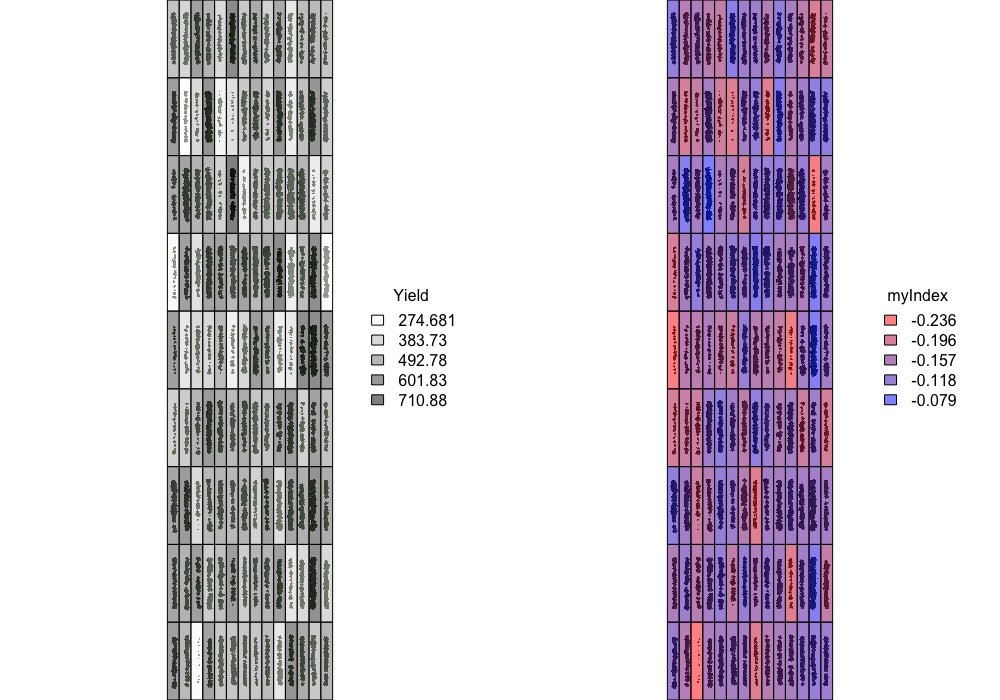
Graphic visualization of trait values for each plot using the fieldShape file and the Mosaic of your preference. Function to use:
fieldPlot.
```r
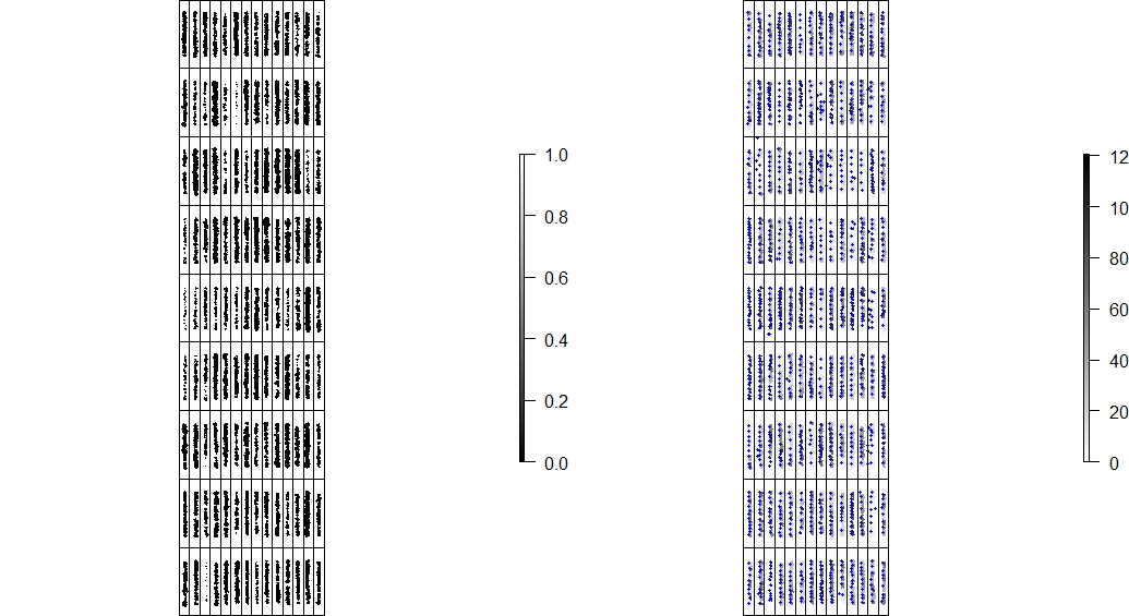
Interpolating colors: c("white","black")
fieldPlot(fieldShape=EX1.Info$fieldShape,fieldAttribute="Yield", mosaic=EX1.Indices, color=c("white","black"), alpha = 0.5)
Interpolating colors: c("red","blue")
fieldPlot(fieldShape=EX1.Info$fieldShape,fieldAttribute="myIndex", mosaic=EX1.Indices, color=c("red","blue"), alpha = 0.5)
```
16. Saving output files
```r
Images (single and multi layers)
writeRaster(EX1.Indices, filename="EX1.Indices.tif", overwrite=TRUE)
EX1.Indices.2 <- rast("EX1.Indices.tif") # Reading the saved image.
FieldShape file
st_write(EX1.Info$fieldShape, ".", "EX1.fieldShape", driver="ESRI Shapefile")
EX1.fieldShape.2 <- st_read("EX1.fieldShape.shp") # Reading the saved shapefile option 01.
CSV file (table)
write.csv(EX1.Info,file = "EX1.Info.csv",col.names = T,row.names = F)
Data.EX1.Info<-read.csv("EX1.Info.csv",header = T,check.names = F) # Reading the saved data table.
``` Menu
Orthomosaic using the open source software OpenDroneMap
Image stitching from remote sensing phenotyping platforms (sensors attached to aerial or ground vehicles) in one orthophoto.
1) Follow the OpenDroneMap’s documentation according to your operating system (Windows, macOS or Linux) to install WebODM.
2) Start WebODM and +Add Project to upload your pictures (.tif or .jpg). Attached is one example of RGB images from experimental trials of UW-Madison Potato Breeding and Genetics Laboratory during the flowering time at Hancock Agricultural Research Station. Flight altitude was 60 m above ground, flight speed was 24 km/h, and image overlap was 75%. Donwload pictures here.
3) After the running process 'completed', download the odm_orthophoto.tif and dsm.tif to upload in R. Then follow the pipeline of FIELDimageR. Donwload the final *odm_orthophoto.tif*.
```r
Uploading file (odm_orthophoto.tif):
EX.ODM<-rast("odm_orthophoto.tif") plotRGB(EX.ODM, r = 1, g = 2, b = 3)
Cropping the image to select only one trial (Selecting the same trial as EX.2 from step.13):
EX.ODM.Crop <- fieldCrop(mosaic = EX.ODM)
Rotating the image using the same theta from step 3:
EX.ODM.Rotated<-fieldRotate(EX.ODM.Crop,theta = 2.3)
Removing soil
EX.ODM.RemSoil<- fieldMask(mosaic = EX.ODM.Rotated)
Building indices
EX.ODM.Indices <- fieldIndex(EX.ODM.RemSoil$newMosaic,Red=1,Green=2,Blue=3, index = c("NGRDI","BGI"), myIndex = c("(Red-Blue)/Green"))
Extracting data using the same fieldShape file from step 5:
EX.ODM.Info<- fieldInfo_extra(mosaic = EX.ODM.Indices$myIndex,fieldShape = EX1.Shape)
EX.ODM.Info$myIndex
```

Parallel and loop to evaluate multiple images
The following code can be used to evaluate multiple images (e.g. root area, leave indices, damaged area, ears, seed, structures, etc.). The example below is evaluating disease damage in images of leaves (affected area and indices). Download the example here.
```r
Images names (folder directory: "./images/")
pics<-list.files("./images/")
Vegetation indices
index<- c("BGI","VARI","SCI")
Loop
system.time({ # system.time: used to compare the processing time using loop and parallel
EX.Table.Loop<-NULL
for(i in 1:length(pics)){
EX.L1<-rast(paste("./images/",pics[i],sep = ""))
plotRGB(EX.L1)
EX.L.Shape<-fieldPolygon(mosaic=EX.L1, extent=T, plot=F) # extent=T (The whole image area will be the shapefile)
EX.L2<-fieldMask(mosaic=EX.L1, index="BGI", cropValue=0.8, cropAbove=T, plot=F) # Select one index to identify leaves and remove the background
EX.L3<-fieldMask(mosaic=EX.L2$newMosaic, index="VARI", cropValue=0.1, cropAbove=T, plot=F) # Select one index to identify demaged area in the leaves
EX.L4<-fieldIndex(mosaic=EX.L2$newMosaic, index=index, plot=F) # Indices
EX.L5<-rast(EX.L3$mask, EX.L4[[index]]) # Making a new rast raster with new layers (demage area and indices)
EX.L.Info<- fieldInfo_extra(mosaic=EX.L5, fieldShape=EX.L.Shape, projection=F) # projection=F (Ignore projection. Normally used only with remote sensing images)
plot(EX.L5,col = grey(1:100/100))
EX.Table.Loop<-rbind(EX.Table.Loop, EX.L.Info$plotValue) # Combine information from all images in one table
}})
rownames(EX.Table.Loop)<-pics
EX.Table.Loop
Parallel
Required packages
library(parallel) library(foreach) library(doParallel)
Number of cores
n.core<-detectCores()-1
Starting parallel
cl <- makeCluster(n.core, output = "")
registerDoParallel(cl)
system.time({
EX.Table.Parallel <- foreach(i = 1:length(pics), .packages = c("raster","FIELDimageR"),
.combine = rbind) %dopar% {
EX.L1<-rast(paste("./images/",pics[i],sep = ""))
EX.L.Shape<-fieldPolygon(mosaic=EX.L1, extent=T, plot=F) # extent=T (The whole image area will be the shapefile)
EX.L2<-fieldMask(mosaic=EX.L1, index="BGI", cropValue=0.8, cropAbove=T, plot=F) # Select one index to identify leaves and remove the background
EX.L3<-fieldMask(mosaic=EX.L2$newMosaic, index="VARI", cropValue=0.1, cropAbove=T, plot=F) # Select one index to identify demaged area in the leaves
EX.L4<-fieldIndex(mosaic=EX.L2$newMosaic, index=index, plot=F) # Indices
EX.L5<-rast(EX.L3$mask, EX.L4[[index]]) # Making a new rast raster with new layers (demage area and indices)
EX.L.Info<- fieldInfo_extra(mosaic=EX.L5, fieldShape=EX.L.Shape, projection=F) # projection=F (Ignore projection. Normally used only with remote sensing images)
EX.L.Info$plotValue # Combine information from all images in one table
}})
stopCluster(cl)
rownames(EX.Table.Parallel)<-pics
EX.Table.Parallel
```

Quick tips (image analyze in R)
1) Changing memory limits in R ```
The rasterOptions() allows you to customize your R session (raster package):
rasterOptions() rasterOptions(chunksize = 1e+09) rasterOptions(maxmemory = 1e+09) ```
2) Reducing resolution for fast analysis
new_mosaic<-aggregate(previous_mosaic, fact=4)
3) Removing previous files after used (more space in R memory): If you do not need one mosaic you should remove it to save memory to the next steps (e.g. the first input mosaic)
rm(previous_mosaic)
4) Using ShapeFile from other software (e.g. QGIS)
ShapeFile <- rgdal::readOGR("Other_Software_ShapeFile.shp") # Option 01
ShapeFile <- terra::vect("Other_Software_ShapeFile.shp") # Option 02
5) Combining ShapeFiles: sometimes it is better to split the mosaic into smaller areas to better draw the shapefile. For instance, the user can combine the split shapefiles to one for the next step as extractions
ShapeFile <- rbind(ShapeFile1, ShapeFile2, ShapeFile3, ...)
6) External window to amplify the RStudio plotting area (It helps to visualize and click when using functions: fieldCrop, fieldRotate, fieldShape, and fieldPolygon). The default graphics device is normally "RStudioGD". To change use "windows" on Windows, "quartz" on MacOS, and "X11" on Linux. ```
Example in macOS (type the following code before running FIELDimageR functions):
options(device = "quartz") ```
YouTube Tutorial
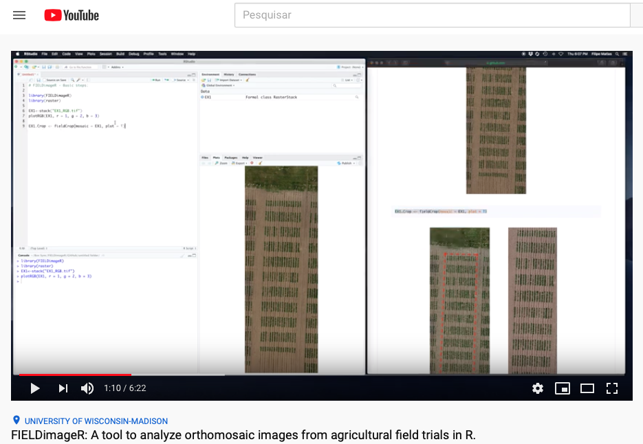
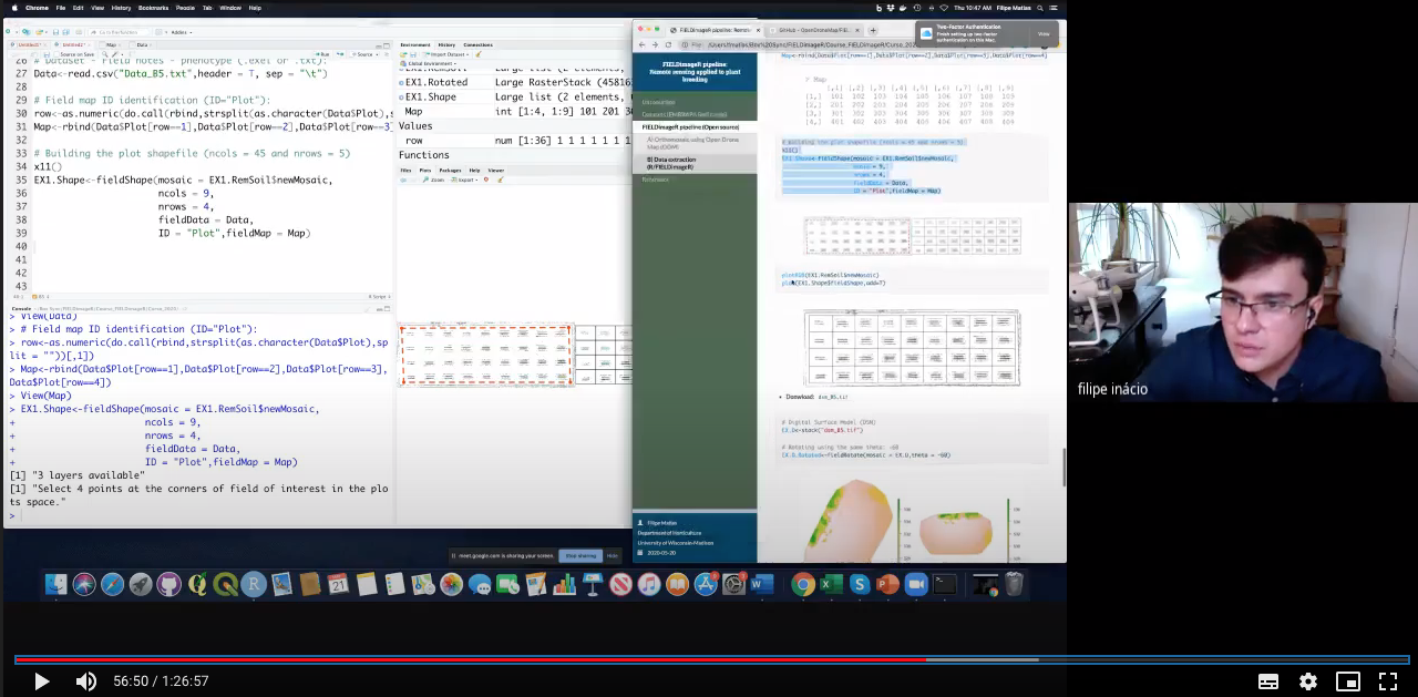
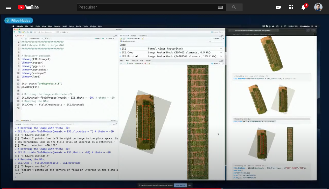
FIELDimageR: A tool to analyze orthomosaic images from agricultural field trials in R (Basic Pipeline)
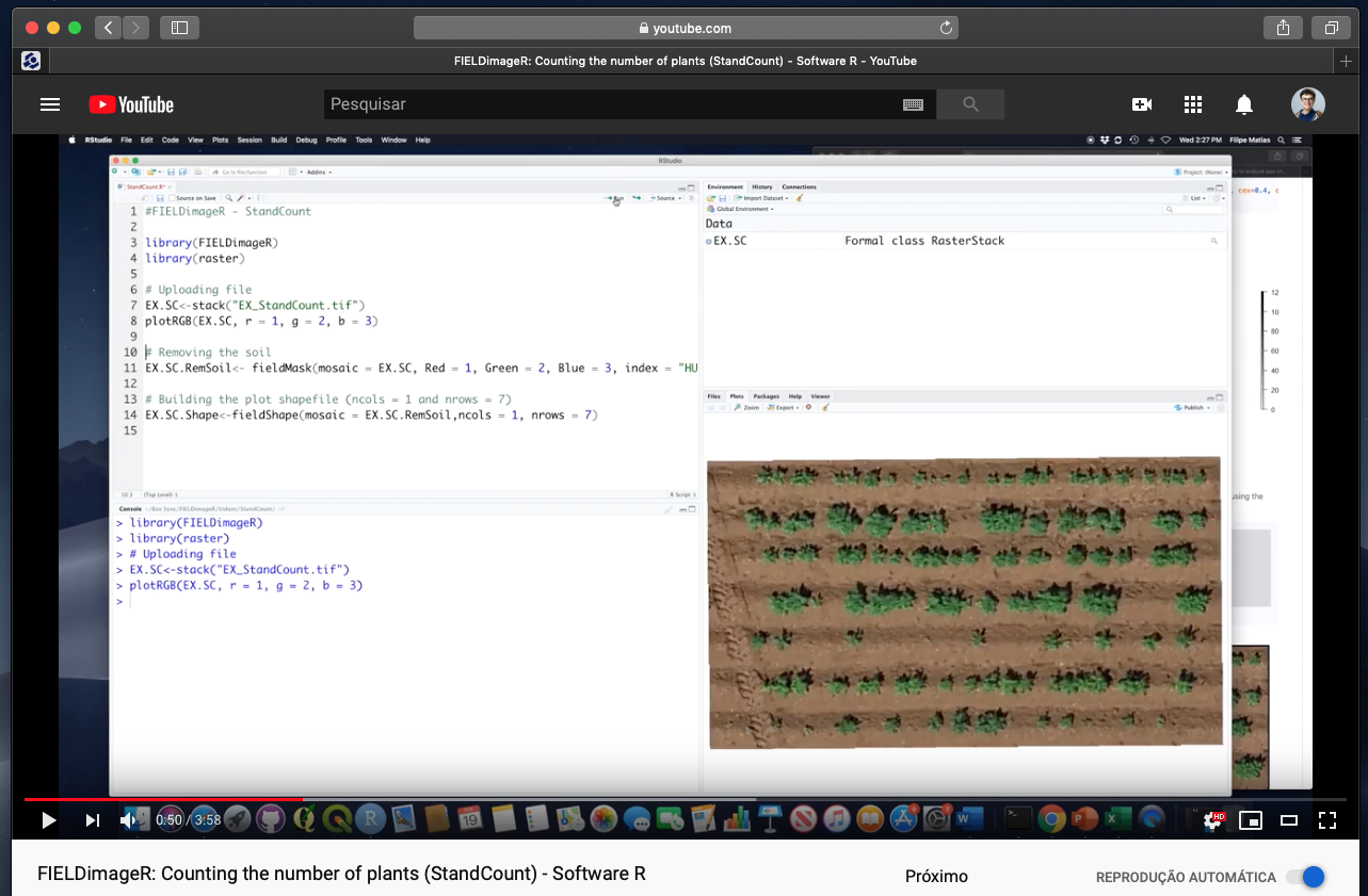
FIELDimageR: Counting the number of plants (fieldCount)
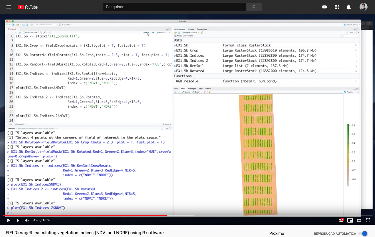
FIELDimageR: Calculating vegetation indices (NDVI and NDRE)
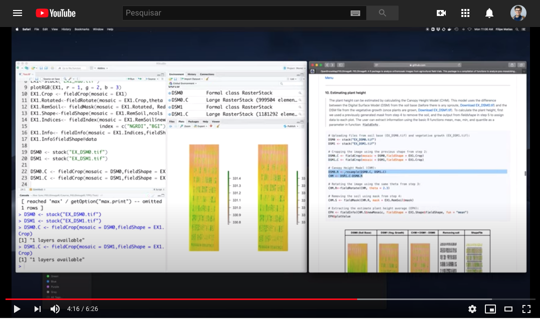
FIELDimageR: Estimate plant height using the canopy height model (CHM)
FIELDimageR courses
- Embrapa Beef-Cattle: https://fieldimager.cnpgc.embrapa.br/course.html
- Embrapa Maize & Sorghum: http://fieldimager.cnpms.embrapa.br/course.html
- Universidade Federal de Viçosa (GenMelhor): https://genmelhor-fieldimager.000webhostapp.com/FIELDimageRCourse%20(2).html
<a href="https://genmelhor-fieldimager.000webhostapp.com/FIELDimageR
Course%20(2).html">
- PhenomeForce (Fridays Hands-On: A Workshop Series in Data+Plant Sciences): https://phenome-force.github.io/FIELDimageR-workshop/
- The Plant Phenome Journal: https://www.youtube.com/watch?v=DOD0ZXJ8tk
<a href="https://www.youtube.com/watch?v=DOD0ZX
J8tk">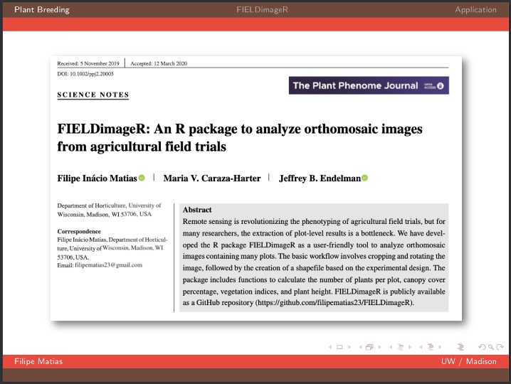
Google Groups Forum
This discussion group provides an online source of information about the FIELDimageR package. Report a bug and ask a question at: * https://groups.google.com/forum/#!forum/fieldimager * https://community.opendronemap.org/t/about-the-fieldimager-category/4130
Developers
Help improve FIELDimageR pipeline. The easiest way to modify the package is by cloning the repository and making changes using R projects.
If you have questions, join the forum group at https://groups.google.com/forum/#!forum/fieldimager
Try to keep commits clean and simple
Submit a pull request with detailed changes and test results.
Let's work together and help more people (students, professors, farmers, etc) to have access to this knowledge. Thus, anyone anywhere can learn how to apply remote sensing in agriculture.
Licenses
The R/FIELDimageR package as a whole is distributed under GPL-2 (GNU General Public License version 2).
Citation
Matias FI, Caraza-Harter MV, Endelman JB. FIELDimageR: An R package to analyze orthomosaic images from agricultural field trials. The Plant Phenome J. 2020; https://doi.org/10.1002/ppj2.20005
- Pawar P & Matias FI.* FIELDimageR.Extra. Pawar P. & Matias FI. FIELDimageR.Extra: Advancing user experience and computational efficiency for analysis of orthomosaic from agricultural field trials. The Plant Phenome J. 2023; https://doi.org/10.1002/ppj2.20083
Author
Acknowledgments
Owner
- Name: OpenDroneMap
- Login: OpenDroneMap
- Kind: organization
- Location: Earth
- Website: https://opendronemap.org
- Repositories: 89
- Profile: https://github.com/OpenDroneMap
Creating the most sustainable drone mapping software with the friendliest community on earth.
GitHub Events
Total
- Watch event: 18
- Fork event: 6
Last Year
- Watch event: 18
- Fork event: 6
Committers
Last synced: 11 months ago
Top Committers
| Name | Commits | |
|---|---|---|
| Filipe Matias | 1****3 | 446 |
| David LeBauer | d****r@a****u | 15 |
| Chris Schnaufer | s****r@e****u | 8 |
| Noah Fahlgren | n****n@g****m | 5 |
| DidierMurillo | d****z@n****u | 3 |
| Bhavya Goel | b****2@g****m | 2 |
| Kenyon Ng | w****k@k****z | 2 |
| pspawar71 | 8****1 | 2 |
| Abdurrahman GÜREL | i****m@a****m | 1 |
| Diego Alves da Silva | d****m@g****m | 1 |
| Piero Toffanin | pt@m****m | 1 |
Committer Domains (Top 20 + Academic)
Issues and Pull Requests
Last synced: 11 months ago
All Time
- Total issues: 42
- Total pull requests: 22
- Average time to close issues: 4 months
- Average time to close pull requests: about 2 months
- Total issue authors: 31
- Total pull request authors: 14
- Average comments per issue: 2.17
- Average comments per pull request: 0.27
- Merged pull requests: 18
- Bot issues: 0
- Bot pull requests: 0
Past Year
- Issues: 0
- Pull requests: 0
- Average time to close issues: N/A
- Average time to close pull requests: N/A
- Issue authors: 0
- Pull request authors: 0
- Average comments per issue: 0
- Average comments per pull request: 0
- Merged pull requests: 0
- Bot issues: 0
- Bot pull requests: 0
Top Authors
Issue Authors
- benlopez15 (4)
- Chris-Schnaufer (4)
- tejasri19 (3)
- eggsale (2)
- agronomofiorentini (2)
- weiyaw (2)
- hanauer48 (1)
- Peter-Jackson22 (1)
- al4112 (1)
- dlebauer (1)
- lucassantoscorrea (1)
- changwushuai (1)
- Lucasprod2022 (1)
- mfm2174 (1)
- tejshahi (1)
Pull Request Authors
- dlebauer (3)
- nfahlgren (3)
- pspawar71 (2)
- pierotofy (2)
- bhavyagoel (2)
- DidierMurilloF (2)
- weiyaw (2)
- filipematias23 (1)
- kant (1)
- diego91964 (1)
- AGurel (1)
- hanauer48 (1)
- Vinay0508 (1)
- Chris-Schnaufer (1)
Top Labels
Issue Labels
Pull Request Labels
Dependencies
- DT * imports
- DescTools * imports
- EBImage * imports
- attempt * imports
- config >= 0.3.1 imports
- doParallel * imports
- fftwtools * imports
- foreach * imports
- git2r * imports
- glue * imports
- grDevices * imports
- maptools * imports
- methods * imports
- plyr * imports
- processx * imports
- raster * imports
- rgdal * imports
- scales * imports
- sp * imports
- spatialEco * imports
- xml2 * imports
- spelling * suggests
- testthat >= 3.0.0 suggests
- rocker/tidyverse 4.1.0 build