https://github.com/davnish/rasvec
A geospatial data handling library.
Science Score: 26.0%
This score indicates how likely this project is to be science-related based on various indicators:
-
○CITATION.cff file
-
✓codemeta.json file
Found codemeta.json file -
✓.zenodo.json file
Found .zenodo.json file -
○DOI references
-
○Academic publication links
-
○Academic email domains
-
○Institutional organization owner
-
○JOSS paper metadata
-
○Scientific vocabulary similarity
Low similarity (10.8%) to scientific vocabulary
Keywords
Repository
A geospatial data handling library.
Basic Info
- Host: GitHub
- Owner: davnish
- License: mit
- Language: Python
- Default Branch: main
- Homepage: https://rasvec.readthedocs.io
- Size: 7.78 MB
Statistics
- Stars: 2
- Watchers: 1
- Forks: 0
- Open Issues: 1
- Releases: 3
Topics
Metadata Files
README.md

Rasvec
This is a Python library designed to streamline the handling of geospatial data, particularly for machine learning applications. Working with geospatial datasets often involves challenges like rasterization, vectorization, and grid creation—this library provides efficient and easy-to-use functions to simplify these processes.
- Documentation : https://rasvec.readthedocs.io
Features
vectors
clip_vector_by_rastercreate_grid_on_vectorrasterize
rasters
patchify(divides the raster into geotagged patches)vectorization
satellite imagery
tms_to_geotiff
view
view_rasters
Example
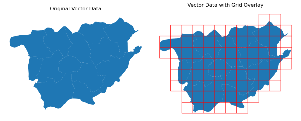
Here's an example of a feature: Generating a grid over a vector file.
```python import geopandas as gpd import matplotlib.pyplot as plt from rasvec import creategridon_vector
gdf = gpd.readfile(r"sampledata/vector/vec/vec.shp")
gridcells = creategridonvector("sample_data/vector/vec/vec.shp", 1000, "grid.shp")
fig, ax = plt.subplots(1,2, figsize=(10, 10)) gdf.plot(ax=ax[0]) ax[0].settitle("Original Vector Data") gdf.plot(ax=ax[1]) gridcells.plot(ax=ax[1], facecolor="none", edgecolor="red") ax[1].settitle("Vector Data with Grid Overlay") ax[0].axis("off") ax[1].axis("off") plt.tightlayout()
``` The output:
Installation
install from PyPi
To install the library from PyPi run the below command in your terminal.
bash
pip install rasvec
install from GitHub
To install the development version from GitHub using Git, run the following command in your terminal.
bash
pip install git+https://github.com/davnish/rasvec.git
acknowledgements
This package was made possible due to the following open source projects.
Owner
- Name: Nischal Singh
- Login: davnish
- Kind: user
- Location: India
- Repositories: 1
- Profile: https://github.com/davnish
GitHub Events
Total
- Create event: 10
- Release event: 9
- Issues event: 6
- Watch event: 2
- Delete event: 4
- Issue comment event: 1
- Push event: 68
Last Year
- Create event: 10
- Release event: 9
- Issues event: 6
- Watch event: 2
- Delete event: 4
- Issue comment event: 1
- Push event: 68
Packages
- Total packages: 1
-
Total downloads:
- pypi 38 last-month
- Total dependent packages: 0
- Total dependent repositories: 0
- Total versions: 7
- Total maintainers: 1
pypi.org: rasvec
A Geospatial data handling library.
- Homepage: https://github.com/davnish/rasvec.git
- Documentation: https://rasvec.readthedocs.io
- License: mit
-
Latest release: 0.1.5
published about 1 year ago
Rankings
Maintainers (1)
Dependencies
- actions/checkout v4 composite
- actions/setup-python v3 composite
- ensure *
- geopandas *
- matplotlib *
- patchify *
- pillow *
- rasterio *
- xyzservices *
- ensure * development
- geopandas * development
- matplotlib * development
- patchify * development
- pillow * development
- pytest * development
- rasterio * development
- tox * development
- xyzservices * development
- geopandas >=1.0.1
- patchify >=0.2.3
- pillow >=11.1.0
- rasterio >=1.4.3
- xyzservices >=2025.1.0