
OSMnx
OSMnx: A Python package to work with graph-theoretic OpenStreetMap street networks - Published in JOSS (2017)
rgee
rgee: An R package for interacting with Google Earth Engine - Published in JOSS (2020)
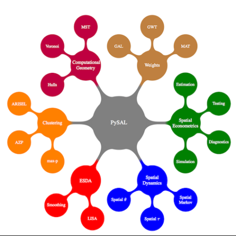
spopt
spopt: a python package for solving spatial optimization problems in PySAL - Published in JOSS (2022)

fractopo
fractopo: A Python package for fracture network analysis - Published in JOSS (2023)

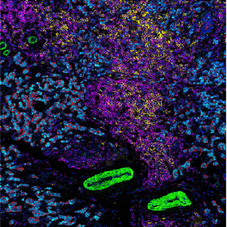
SCIMAP
SCIMAP: A Python Toolkit for Integrated Spatial Analysis of Multiplexed Imaging Data - Published in JOSS (2024)

forestatrisk
forestatrisk: a Python package for modelling and forecasting deforestation in the tropics - Published in JOSS (2021)

gridwxcomp
gridwxcomp: A Python package to evaluate and interpolate biases between station and gridded weather data - Published in JOSS (2025)
shar
shar: An R package to analyze species-habitat associations using point pattern analysis - Published in JOSS (2021)

spatial-efd
spatial-efd: A spatial-aware implementation of elliptical Fourier analysis - Published in JOSS (2017)

geocmeans
geocmeans: An R package for spatial fuzzy c-means - Published in JOSS (2023)

KLRfome - Kernel Logistic Regression on Focal Mean Embeddings
KLRfome - Kernel Logistic Regression on Focal Mean Embeddings - Published in JOSS (2019)
srai
Spatial Representations for Artificial Intelligence - a Python library toolkit for geospatial machine learning focused on creating embeddings for downstream tasks

chromatic_tda
Tool to compute six-packs of persistence diagrams for chromatic point clouds [packaged on PyPI]


Pyinterpolate
Pyinterpolate: Spatial interpolation in Python for point measurements and aggregated datasets - Published in JOSS (2022)

who-owns-mass-processing
Deduplicates property owners in Massachusetts using the MassGIS standardized assessors' parcel dataset and the OpenCorporates Bulk Data product.
sdmTMB
:earth_americas: An R package for spatial and spatiotemporal GLMMs with TMB

gval
A high-level Python framework to evaluate the skill of geospatial datasets by comparing candidates to benchmark maps producing agreement maps and metrics.

https://github.com/benchmark-urbanism/cityseer-api
Computational tools for urban analysis

https://github.com/afsc-gap-products/akgfmaps
AFSC fishery-independent survey geospatial features and maps


envi
Environmental Interpolation using Spatial Kernel Density Estimation

greenexp_r
This is a R toolkit and developer version package to estimate multidimensional aspects of greenness and nature exposure, such as availability, accessibility and visibility using various geospatial data and models

geomatique_avec_r
Géomatique avec R - Pour la réalisation de traitements reproductibles de l’information géographique.
cartographie_avec_r
Cartographie avec R - Créer des cartes thématiques reproductibles.

pyspatialhistologyanalysis
Package using StarDist and Python that performs object detection and spatial analysis on H&E images

SEraster
Spatial Experiments raster - a rasterization preprocessing framework for scalable spatial omics data analysis

gval
A Python framework to evaluate geospatial datasets by comparing candidate and benchmark maps to compute agreement maps and statistics.


forestatrisk-tropics
:earth_africa: :pencil: Modelling and forecasting deforestation in the tropics

https://github.com/blasbenito/spatialrf
R package to fit spatial models with Random Forest


geothermal_esda
This repository contains exploratory spatial data analysis (ESDA) functions and scripts. These functions are designed for geothermal spatial datasets, and are applicable to other spatial datasets.

https://github.com/fgazzelloni/oregonfrogs
Dataset containing radio frequencies, geo-locations, and habitat types for Oregon frogs

glmmfields
R package for Bayesian spatial and spatiotemporal GLMMs with possible extremes

gecko
GECKO is a suite of geographical analysis functions aimed primarily at ecology and conservation science studies.
11521-adv-geo-comp
Syllabus and materials for redesigned 11.521, Advanced Geographic Computation for Urban Planning

urban-change-google-25d
Python and Google Earth Engine workflows for detecting and classifying urban change using Google’s Open Buildings 2.5D Dataset, with a focus on informal settlements in Nairobi. Includes scripts for processing, typology classification, slum-level validation prep, and city-scale spatial analysis.

city2graph
Transform geospatial relations into graph representations designed for spatial analysis and Graph Neural Networks (GNNs).

criteria3d
CRITERIA-3D is a three-dimensional agro-hydrological model for small catchments.

carto-lab-docker
A versioned Docker container running a pre-configured JupyterLab for reproducible spatial data science. Officially supported by the Research Data Centre (FDZ) at IOER. This is the community mirror for issues, discussions, and contributions.

marex
Marine Extremes detection, identification, and tracking/merging for Exascale Climate data

https://github.com/betsaka/mapme_impact_training
Tutorial in French and English on impact evaluation with Mapme tools applied to protected areas in Madagascar.

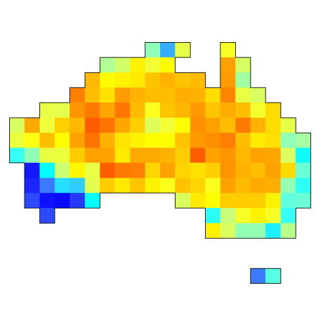
https://github.com/cjabradshaw/aussoilhg
Predicting continental distribution of soil mercury concentration in Australia


geospatial_artif_intell_s110056
中国地质大学(武汉)地理信息工程学院开设的一门选修课。An optional curriculum held by School of GI Engineering, CUG

perceived_safety_choices
The model that has been uploaded to this repository aspires to describe routing behavior of micro-mobility modes, e.g., e-bikes and e-scooters, in relationship with traditional modes, e.g., private car and walking.

https://github.com/hautaniemilab/histolytics
Interpretable Analysis of Histological WSIs

fmap
An R package for creating Fresnel Maps, a new thematic mapping technique in which spatial data is visualised to equal-area concentric circular zones (or annuli).
https://github.com/bodenmillergroup/imcdataanalysis
R based workflow for multiplexed imaging data

grids
A python tool for extracting time series subsets of n-dimensional spatiotemporal arrays

fieldstack
Reusable R notebooks, scripts, and tools for applied data work and evaluation — built for use in the field across health, gender, climate, and education programs.
jupyter-book-nfdi4biodiversity
Public repository for the Jupyter book (original repository: https://gitlab.hrz.tu-chemnitz.de/ioer/fdz/jupyter-book-nfdi4biodiversity) with training material on how to connect to the IOER Monitor API and the GBIF Database API to query and process spatial data.